
Cut and Fill Quantities on Ontario Grading Plans
Cut and fill quantities compare defined ground surfaces within a stated area. They explain where a grading design removes ground and adds material, but do not establish truck counts, construction cost or material suitability. Review quantity assumptions, cut and fill balance, and the distinction between grading volume and excess soil before relying on the total.
What cut and fill quantities actually represent
The useful question is not simply, “What is the total?” It is, “What does this total include, and what decisions can it support?” A quantity becomes meaningful when its surfaces, boundaries, material assumptions and drawing revision are clear. This guide explains those distinctions without turning a preliminary design calculation into a hauling instruction or a promise about soil suitability.
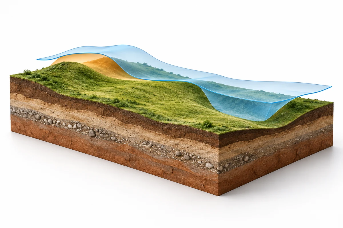
Cut identifies ground that a design proposes to remove relative to its starting surface. Fill identifies space that the design proposes to build up. A surface comparison can identify both within the same property: a higher area may need cutting while a lower area needs filling. The calculation describes geometry first, not the condition or eventual destination of each material.
Imagine two transparent sheets showing the existing and proposed ground. The space between them changes across the site. A quantity calculation brings those differences together within a selected boundary. Yet the sheets do not reveal buried debris, changes in soil layers or whether excavated material is appropriate for a particular placement. Those are separate questions requiring appropriate information and professional assessment.
Gross movements and net balance answer different questions
A report may show separate cut and fill totals and a net difference. The separate totals describe the scale of change more clearly than the net figure alone. Two designs can have a similar net balance while involving very different amounts of excavation and placement. Therefore, a small net figure should not be read as evidence that little work is involved.
Ask the report author what positive and negative values mean. Different summaries can present the sign convention differently. Also ask whether the net figure compares unadjusted geometric volumes or incorporates documented material assumptions. A labelled quantity schedule is much more useful than a single unexplained number in an email.
Start with the two surfaces being compared
Before relying on cut and fill quantities, identify the starting surface and the target surface. “Existing to proposed” can sound complete while leaving important details unresolved. Existing ground measured before stripping is not the same starting point as ground measured after stripping. Likewise, proposed finished landscaping is not necessarily the surface used to calculate the underlying earthwork.
Existing ground needs a date and a reliable reference
A topographic survey records conditions at a particular time. If demolition, stockpiling or excavation has occurred since that survey, the model may no longer represent the starting condition for the intended work. The owner should tell the designer about intervening activities rather than assume they are minor. A newer drawing date does not necessarily mean the underlying survey was updated.
The elevations also need a consistent vertical reference. Two files may look aligned on a screen while using different elevation references or offsets. Resolving that mismatch is technical coordination, not a reason for an owner to alter levels manually. Ask the responsible team to confirm that the survey, grading model and associated drawings use compatible references.
Finished grade is different from the surface below it
A lawn, paved driveway and building footprint do not all have the same construction layers. A finished surface can include materials that are accounted for separately from general earth fill. Consequently, a calculation to finished grade may answer a different question from a calculation to formation or subgrade. The report should identify which surface is used in each area.
Do not assume that a single allowance applied across the whole lot resolves every layer. The relevant build-up can vary with the design and specifications. Instead, request a clear explanation of what is represented in the model and what is scheduled elsewhere. This keeps the quantity interpretation tied to the actual project rather than a generic rule.
The calculation boundary can change the result
The property boundary and the earthwork calculation boundary are not necessarily identical. Some areas may remain undisturbed, sit outside the survey coverage or belong to a separate construction package. A calculation might also exclude a building excavation even though the building appears on the same drawing. Without a marked boundary, comparing totals from different reports can be misleading.
For example, one contractor may consider the entire disturbed area while another prices only the landscape grading shown around the building. Neither total can be compared fairly until the scopes are aligned. Ask for the calculation extent to be shown on a plan, together with any holes or excluded areas within it.
Check edges, transitions and unknown areas
Boundary transitions deserve particular attention. The model must connect proposed work to the conditions around it, but missing information beyond a survey edge may limit what can reasonably be calculated. A neat-looking surface can still depend on assumptions. Where data are incomplete, the report should identify the limitation rather than conceal it behind extra decimal places.
Retained trees, structures and protected areas can also affect the usable work area. Their presence on a drawing does not automatically explain how they were treated in the volume calculation. Ask whether these areas were excluded, represented with specific constraints or left for later coordination. This question is especially useful when a project has developed in several separate drawing packages.
Separate the quantity from the material
A geometric cut volume does not establish that every excavated material can replace every fill requirement. Material suitability depends on the intended use and the relevant technical and environmental assessment. Keeping these questions separate prevents an apparently balanced model from becoming an unsupported reuse promise.
Topsoil is not a general substitute for engineered fill
A project may need to account for topsoil separately from underlying material and from imported landscaping products. The owner’s practical question is whether stripping, storage and final landscaping are included in the quantity schedule or assigned elsewhere. Without that distinction, the same material can appear in one estimate as available fill and in another as a separate removal item.
Retaining material on site also raises coordination questions. Where could it be stored without conflicting with access, drainage or protected areas? When would it be available for reuse? Those questions should be resolved through the project’s design and construction planning, not by treating an open area on a drawing as automatic storage permission.
Unknown or unsuitable material needs its own decision
Unexpected fill, organic material or buried obstructions can change the work beyond what a surface model describes. Whether a material is suitable for a particular engineered placement is a technical decision for the appropriately retained professional. It should not be inferred from colour, appearance or a contractor’s ability to move it.
Environmental suitability is a different question again. Material might satisfy a physical requirement for one use yet need a separate environmental assessment before movement or acceptance elsewhere. Conversely, an environmental classification does not itself establish engineering performance. Ask who is responsible for each determination and how the conclusions will be communicated to the rest of the team.
Rock and imported products should not disappear into one total
A surface comparison alone does not map the underground boundary between soil and rock. Where that distinction matters, the relevant investigation and construction records become important. Similarly, a requirement for a specified imported product is not necessarily met by a surplus of site material. A useful schedule preserves these distinctions instead of presenting every cubic metre as interchangeable.
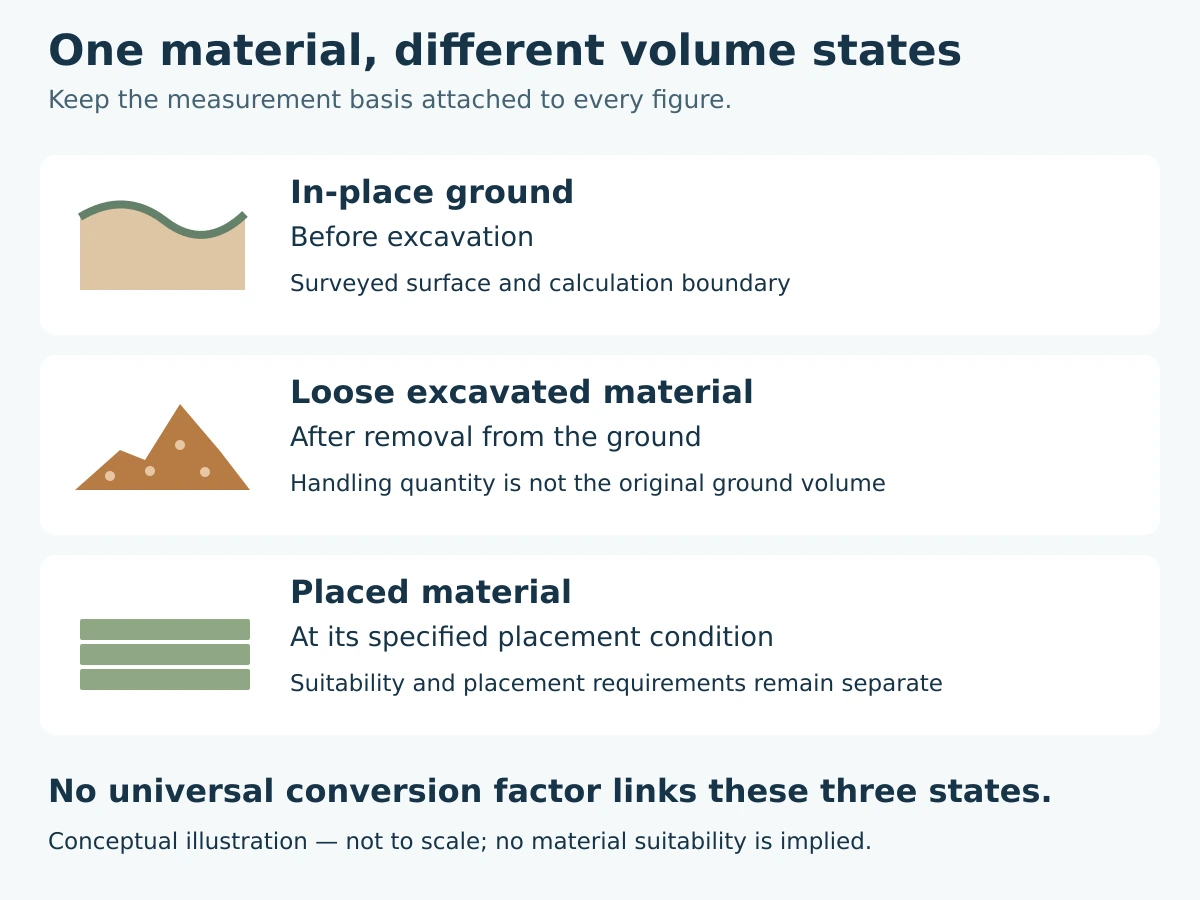
In-place, loose and compacted volumes are not interchangeable
Cut and fill quantities can refer to material in different physical states. Ground before excavation, material after excavation and material placed to a specified condition are not automatically represented by the same volume. That is why a geometric figure cannot simply be relabelled as truck capacity or a finished fill delivery.
There is no single conversion factor appropriate to every Ontario site and every material. The assumptions depend on the material, its condition, the intended placement and the purpose of the estimate. If a report applies an adjustment, ask who established it, what it represents and what evidence supports its use for this project.
Keep the original figure visible
A helpful quantity summary distinguishes the original model result from any adjusted planning quantity. Otherwise, later readers may not know whether an allowance has already been included and may add it again. The same problem occurs when a spreadsheet is copied into a quotation without its notes.
Units matter too. A volume in cubic metres and a mass recorded by a scale are different measurements. Reconciling them requires an agreed basis, not just a change to the column heading. Owners should ask for a documented explanation whenever reports move between volume, weight, loads and payment items.
Why a balanced design may still involve imports or exports
A balanced geometric result is not a complete material-management plan. The cut material may differ from the required fill. Some excavated material may be unavailable when needed, and some construction products may have to be supplied separately. These distinctions can exist even when the net surface difference is small.
Timing is another consideration. Material excavated early may need to remain somewhere while other work proceeds. If the approved site arrangement cannot accommodate that storage, the practical sequence may differ from an idealized transfer between two areas. The quantity model does not by itself settle the construction sequence or authorize temporary stockpiles.
Do not change drainage merely to chase a smaller net number
The grading design must serve the site’s engineering and approval requirements. Altering levels simply to retain more material can affect drainage routes, entrances, adjacent properties and other coordinated elements. A smaller export assumption is not sufficient justification for changing an approved design.
If the owner wants alternatives explored, the designer should assess them against the project’s constraints. Compare the implications as well as the headline quantity: what changes in the drawings, what further review is needed, and what uncertainty remains? This is a design decision, not an instruction to spread surplus soil wherever space appears available.
Design quantities and payment quantities can differ
Cut and fill quantities prepared for design coordination do not automatically define the contractor’s payment entitlement. A construction contract may use a particular measurement method, define separate items and allocate specific responsibilities. Owners should understand that basis before comparing prices or approving a change.
For a specific illustration, the historical November 2014 OPSS.PROV 206 text reproduced in the Ministry of Transportation’s April 2025 package describes actual measurement of earth excavation for grading using in-place volume derived from field cross-sections before grubbing and after the work. This is a contract-specification example, not a universal requirement for residential grading. The applicable contract, edition and amendments must be checked. See the official MTO package containing section 206.09.
Agree on evidence before the starting condition changes
If a future payment depends on measurement, the parties need to know what records will support it. Waiting until excavation is complete can make the original condition difficult to establish. The owner should ask the contract administrator or other responsible adviser which surveys, records and approvals the agreement requires.
This does not mean every small project needs the same measurement system. It means the evidence should suit the contract and the decision. A preliminary allowance, a fixed-price scope and a measured payment item are different arrangements. A grading-plan number should not silently move between those roles.
Compare quotations on scope, not volume alone
Two quotations can show different quantities because they include different activities. One may include stripping and temporary handling; another may exclude those activities. One may carry an explicit allowance for unresolved conditions while another leaves them for a later change. Neither difference can be understood from the total price alone.
Request a clear inclusion and exclusion schedule. Then separate genuine design differences from commercial assumptions. This helps the owner decide which questions need engineering clarification and which belong with the contractor or contract adviser. It also avoids asking the designer to certify a price or hauling commitment outside the agreed engineering scope.
When soil leaves the project area, another set of questions begins
Ontario’s excess-soil framework is separate from a grading volume calculation. Provincial guidance explains that excavated soil or crushed rock becomes excess soil when it leaves the project area. Beneficial reuse depends on conditions including appropriate quality, quantity and purpose. Some projects also require planning, assessments, registration and tracking, subject to applicable provisions and exemptions. Responsibility for key compliance decisions remains with the project leader even where others undertake tasks. Consult Ontario’s project-area excess-soil guidance and the current rules with the appropriately qualified adviser.
A line reading “surplus” in a quantity summary is therefore not destination approval. Before relying on an off-site route, identify who will confirm the applicable requirements and receiving-site acceptance. A low-cost destination is not a workable assumption until the relevant acceptance and project obligations have been addressed.
Ask for a route, not just a removal allowance
For planning purposes, the owner needs to understand the unresolved dependencies. Is the destination known? Is its acceptance based on the material actually expected? What happens if that route becomes unavailable? These are useful coordination questions, not a substitute for the assessments and records required for the particular movement.
Keep the environmental advice attached to the material and movement it concerns. An answer about one area of a site should not quietly become an answer about every excavation. Similarly, a quantity update can change the assumptions that were discussed earlier. The project team should know when a design revision needs to be referred back to the responsible adviser.
A useful quantity-review record
Owners do not need to reproduce the designer’s calculations to ask effective questions. They need a short, consistent record that explains what the figures mean. The following review prompts help keep cut and fill quantities connected to their intended purpose.
- Purpose: Is the report for design comparison, budgeting, tender coordination or an agreed payment measurement?
- Inputs: Which survey, drawing revision and surface files were used, and when were they prepared?
- Extent: Which areas are included, excluded or dependent on missing information?
- Surfaces: Does the comparison use existing, stripped, formation or finished ground?
- Materials: Which items are separately accounted for, and who confirms their suitability?
- Adjustments: Are any changes from geometric to planning quantities visible and explained?
- Responsibility: Who resolves design, measurement, construction and excess-soil questions?
Save the answers with the quantity report rather than in separate messages that may be lost. When someone forwards a total, the qualifying notes should travel with it. That small documentation habit can prevent a preliminary figure from being mistaken for a final instruction.
Use uncertainty to identify the next decision
An unknown is useful when it is specific. “Subject to site conditions” says little about what the owner should do next. “Existing stockpile extent not surveyed” identifies a missing input. “Material reuse suitability not assessed” identifies a different task. Ask the team to describe the uncertainty clearly enough that responsibility and timing can be assigned.
Not every uncertainty must be eliminated before early design proceeds. However, the team should avoid presenting an unresolved assumption as a confirmed saving. A staged approach can preserve momentum while making clear which decisions remain provisional and which information is needed before construction or contracting commitments.
Watch for double counting between work packages
When several contractors or consultants contribute figures, the owner needs a clear division between packages. Building excavation, utility trenches, pavement construction and landscape grading may overlap spatially while being measured for different purposes. Adding their totals without checking the boundaries can count the same space twice. Conversely, assuming each item is covered elsewhere can leave a real omission.
A simple coordination drawing or inclusion schedule can make those interfaces visible. It should identify which package owns each quantity and how related allowances are treated. For example, a report might exclude a building footprint while another includes excavation beyond that footprint. The team should explain the interface rather than rely on the titles of the two reports.
This matters when cut and fill quantities are updated after a building or servicing change. The revised information needs to reach everyone whose scope depends on it. Updating the grading drawing alone may not update a contractor’s spreadsheet or a separately prepared allowance. Ask who will coordinate the affected documents and confirm that they refer to compatible revisions.
Match the level of detail to the decision
An early comparison between design options does not need to pretend it is a final construction account. Its value may be to show which option creates more uncertainty or changes the likely movement of material. Label the purpose plainly and retain the unresolved assumptions. That allows the owner to compare options without mistaking preliminary precision for certainty.
Later decisions may need more complete information. Before a contract is settled, the parties should understand the agreed measurement basis and exclusions. The parties also need to address applicable requirements and acceptance before relying on a proposed off-site movement. Before final payment is assessed, the required records matter. These are successive decisions, not interchangeable uses of one number.
The practical test is whether a reader can tell what the cut and fill quantities are suitable for today. If the answer requires a long explanation that is absent from the report, request that explanation in writing. A brief statement of purpose and limitations is often more useful than adding further decimal places to an uncertain figure.
Illustrative scenario: a small net balance, several separate decisions
This is a hypothetical example, not an Elmid Design Inc. project or a construction recommendation. An Ontario owner receives a grading summary that appears close to balanced. The owner initially assumes that no material will need to leave the property. A review meeting shows why the figure needs interpretation before that conclusion can be drawn.
First, the summary compares the surveyed ground with proposed finished surfaces around a building. The basement excavation belongs to another package. Second, the landscape work includes a separate topsoil allowance. Third, the suitability of excavated material for the planned fill has not yet been established. These are different issues; changing one number cannot resolve all three.
What the team clarifies
The designer identifies the model boundary and the surfaces used. The owner asks the relevant consultants to explain material-related information and outstanding assessments. Meanwhile, the contractor clarifies what its quotation includes and how changes will be documented. The parties do not use the apparent balance as permission to change drainage levels or move soil to an unconfirmed destination.
After this review, the owner has a clearer decision record even if the final construction quantity is not yet known. The benefit is not a guaranteed reduction in cost. It is knowing which assumptions support the budget, which items are separate and which questions must be answered before commitments are made.
Keep quantity changes traceable through construction
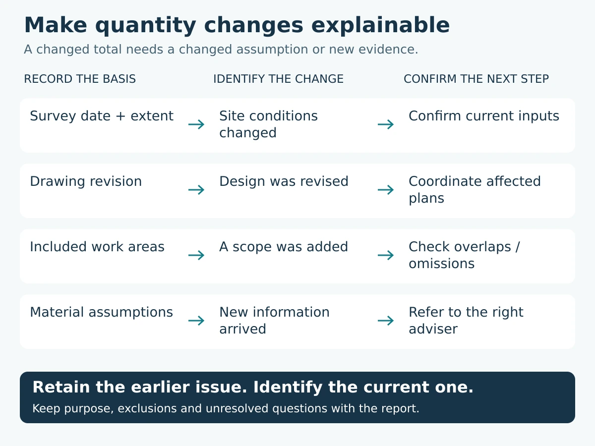
Cut and fill quantities can change when the design, the starting condition or the calculation scope changes. A revised total should therefore come with a reason. Otherwise, the owner cannot tell whether the difference reflects a genuine design adjustment, additional information or a correction to the earlier calculation.
Separate design revision from field discovery
A changed driveway arrangement is different from discovering material that was not represented in the available information. Both may affect the work, but they should not be described as the same event. A clear record identifies what changed, who assessed it and which drawings or instructions were affected.
Where site observations conflict with the assumed conditions, refer the issue to the responsible team before treating the old quantity as authoritative. Photographs can help explain the question, but they do not automatically replace survey measurements, technical assessment or contract records. The evidence must fit the decision being made.
Retain superseded reports without confusing the current one
Keep earlier reports for traceability, clearly marked as superseded where appropriate. The current issue should identify its revision and purpose. If a quotation was based on an earlier issue, record that fact rather than overwriting the history. This makes later discussions about scope and changes more understandable for everyone involved.
At closeout, distinguish the records of constructed elevations from the records used for material movement or payment. Each may support a different conclusion. A finished grading survey alone does not necessarily establish every quantity moved during construction, and a stack of delivery tickets does not demonstrate that final drainage matches the approved design.
How Elmid Design Inc. can help clarify the grading scope
Elmid Design Inc. can discuss the grading-design information needed for your project and clarify the engineering deliverables in its agreed scope. Bring the current survey, proposed building layout, relevant review comments and any existing quantity report. Explain whether your immediate decision concerns a design option, a quotation comparison or an unresolved site condition.
Ask explicitly whether a quantity calculation, model handoff, construction review or other additional task is included in the proposed engagement. Do not assume that a grading drawing includes every estimating or contract-administration service. Surveying, geotechnical assessment, environmental qualified-person work, hauling and contractor operations also require clear responsibility; this article does not offer those as bundled services.
The most productive starting point is a shared description of the problem. If the concern is an unexplained export allowance, bring the allowance and its assumptions. If two reports disagree, bring both complete reports, not only their totals. That allows the team to identify the actual difference before deciding what additional work is warranted.
Frequently asked questions about cut and fill quantities
Does every grading plan include a detailed quantity calculation?
Do not assume so. The drawing purpose, municipal submission requirements and consultant’s agreed scope determine what is provided. Ask whether quantities are included, what they cover and whether a separate report is needed for your intended decision.
Can I use the net cut figure to order trucks?
Not without further clarification. A net geometric figure does not establish loose loading volume, material condition, receiving-site acceptance or the contractor’s transport arrangements. Have the responsible parties confirm the basis before using it for a commitment.
Does balanced grading mean no soil leaves the property?
No. A geometric balance does not prove that excavated material meets the required uses or is available at the right time. Separate excavations, material classifications and construction sequencing can still create import or export requirements.
Why do two estimates show different cut and fill quantities?
They may use different surveys, boundaries, proposed surfaces, drawing revisions or allowances. Compare those inputs first. If they match, ask the report authors to explain the remaining difference rather than averaging the totals or choosing the lower number.
Can soil be called clean because it looks normal?
Appearance is not evidence that establishes the applicable environmental quality. The necessary assessment depends on the project and intended movement. Keep that determination separate from the geometric calculation and from engineering suitability for a particular placement.
Can we raise the yard to avoid exporting material?
Only a properly assessed and authorized design change could support that approach. Raising ground can affect drainage, adjacent properties and other project requirements. An earthwork saving does not override the approved grading arrangement or applicable permissions.
What should I send when asking about an unexplained quantity?
Send the complete quantity report with its notes, the referenced drawing revision, the available survey and the quotation or decision it affects. Identify any site work completed since the survey. These records help distinguish missing information from a genuine design or scope difference.
Geographic Locations That We Service:
Elmid Design Inc. provides grading and drainage engineering across Ontario service areas. The agreed scope depends on the property, proposed work and applicable review requirements.
We provide engineering services across a wide range of municipalities, each with its own requirements and review processes.
Toronto and Surrounding Areas
We provide engineering services in Toronto and provide grading engineering resources through our Toronto grading plan page.
Our service area also includes Oshawa, Pickering with our Pickering grading plan resources, and Clarington.
We also provide engineering services in Ajax through our Ajax grading plan resources, Whitby, Brock, Scugog, and Uxbridge, including our Uxbridge grading plan resources.
Halton Region
Within Halton Region, we provide engineering services in Burlington, including projects requiring Burlington grading plans.
We also provide engineering services in Halton Hills, supported by our Halton Hills grading plan resources.
Our service area also includes Milton and Oakville, including our Oakville grading plan resources.
Peel Region
Within Peel Region, we provide engineering services in Brampton, including projects requiring Brampton grading plans.
We also provide engineering services in Mississauga through our Mississauga grading plan resources and Caledon through our Caledon grading plan resources.
York Region
Within York Region, we provide engineering services in Vaughan and provide information about Vaughan grading plans.
We also provide engineering services in Aurora through our Aurora grading plan resources and East Gwillimbury through our East Gwillimbury grading plan resources.
Additional service areas include Georgina with our Georgina grading plan resources, Markham with our Markham grading plan resources, and Newmarket with our Newmarket grading plan resources.
We also provide engineering services in Richmond Hill with our Richmond Hill grading plan resources, Whitchurch-Stouffville through our Whitchurch-Stouffville grading plan resources, and King through our King grading plan resources.
Our service area also includes Bradford West Gwillimbury.
Other Southern Ontario Cities and Towns
We provide engineering services in many additional Southern Ontario communities, including Hamilton, St. Catharines, Niagara-on-the-Lake, Brant, Cambridge, Kitchener, Waterloo, and Woodstock.
We also provide engineering services in Guelph, Centre Wellington, Shelburne, Orangeville, New Tecumseth, Essa, Collingwood, Wasaga Beach, and Barrie, including our Barrie grading plan resources.
Additional service areas include Midland, Orillia with our Orillia grading plan resources, Ramara, Minden Hills, North Kawartha, Kawartha Lakes, Peterborough, Selwyn, and Brighton.