
Rock Check Dam vs Silt Fence: Ontario ESC Guide
Rock check dams and silt fences address different flow conditions. A rock flow check belongs to a designed construction conveyance; an ordinary sediment fence addresses sheet flow. Compare construction swale conditions, sheet flow and concentrated flow, and downstream treatment before treating either measure as a substitute. Elmid Design Inc. provides site-specific ESC engineering, not installation.
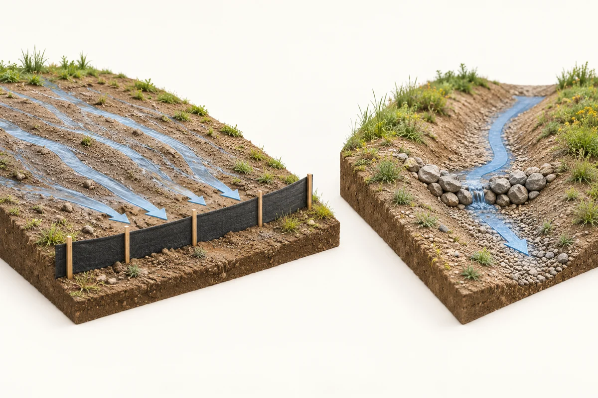
Rock check dam vs silt fence: start with the flow
The useful comparison is not stone versus fabric. It is the job each control must perform at a particular point on the site. Water moving broadly across a disturbed surface creates a different design question from water gathered into a defined temporary channel. A familiar product name does not answer that question.
For an owner, this distinction helps explain why two drawings may show different controls on the same project. A perimeter location and a construction swale can receive different kinds of runoff. Therefore, the project may need both types of measure, other controls, or a different arrangement altogether. The site-specific design must establish the combination.
This guide concerns temporary construction-site controls. It does not provide a detail for building a dam, changing a natural stream or redirecting water onto another property. A natural watercourse, wetland or other natural water feature is outside this comparison. Do not interpret the word “ditch” on an informal sketch as proof that a channel is artificial or available for alteration.
Sheet flow and concentrated flow are different design inputs
Sheet flow describes water spread relatively shallowly across a surface. Concentrated flow gathers into a more defined route. On a construction site, that route may be a designed swale, but it may also be an unintended low strip or a path created by changing site conditions. The designer needs to understand the actual route rather than rely on the surface’s name.
Fisheries and Oceans Canada’s land-based ESC guidance recognizes that exposed ground and changing drainage affect erosion risk. Its national procedure concerns land work near water and is not a stand-alone approval. For a rock check dam and silt fence comparison, review the flow setting and its changes, not assume the initial layout remains suitable throughout construction.
What a designed rock flow check is intended to do
STEP’s rock check dam guidance describes temporary flow interruption in low-flow construction conveyance channels. Reducing the speed of water can reduce its erosive action. The appendix also warns that the limited ponding capacity does not provide effective settling of fine particles. It excludes natural watercourses and other natural water features.
That is a narrower purpose than “stop all dirty water.” If a drawing shows a rock flow check, ask which construction conveyance it serves and how that conveyance connects to the rest of the ESC arrangement. The answer should identify an actual location and a design purpose, not simply a standard detail number.
A control shown across a temporary swale also raises questions about the channel around it. Where does water arrive? What protects the adjacent ground? Where does it go next? These are connected parts of the design discussion. The rock symbol alone does not explain the whole route.
Construction swale check dams are not sediment ponds
A temporary rock flow check should not be described as a small version of every sediment-treatment facility. A sediment pond or trap has its own design purpose and requirements. This comparison does not size those facilities or establish whether they are necessary on a particular project.
Instead, keep the questions separate. First, what must happen within the conveyance? Second, what treatment does the runoff need before discharge to the next receiving feature? Third, which party establishes those requirements? Combining the questions into one promise that “the rocks will filter it” can conceal a missing design decision.
The US EPA’s check-dam fact sheet similarly distinguishes flow reduction from a complete sediment-control system. It notes potential effects on channel capacity and downstream erosion. This is supplementary technical background, not an Ontario standard; its numerical design criteria must not be imported into an Ontario drawing without the applicable professional and authority review.
What an ordinary silt fence can and cannot establish
STEP’s sediment control fence appendix identifies silt fence as a sheet-flow settling control. It specifically distinguishes that function from filtering fine particles and from obstructing a concentrated flow path. The fence’s location therefore needs a drainage reason, not merely a convenient property boundary.
This also explains why a continuous line around a site is not, by itself, evidence of a complete design. Some boundaries may receive runoff while others may not. A drawing needs to explain the intended control function where it matters. Boundary identification, access management and sediment control are related site issues, but they are not identical tasks.
When reviewing a plan, ask the designer to identify the area contributing runoff to the fence. Then ask what changes during excavation, servicing and later work. If the contributing area or flow route changes, the earlier selection may need review even when the fence itself has not moved.
More fabric does not automatically solve a flow mismatch
Suppose a site team reports repeated damage at one location. Replacing the damaged material may be necessary under the maintenance arrangements, but it does not establish why that location keeps failing. The question may involve the arriving flow, the arrangement, implementation, maintenance or several factors together.
When comparing rock check dams and silt fences, the owner’s useful request is for a documented explanation of the recurring condition. Do not instruct the contractor to add arbitrary layers, raise a barrier or block an alternative route based on this article. Changes must follow the project response process and any required design review.
The EPA silt-fence background emphasizes placement and the consequences of water escaping around a fence. It supports asking about the complete alignment and its ends. However, the US document is not a substitute for the Ontario project’s accepted details or local requirements.
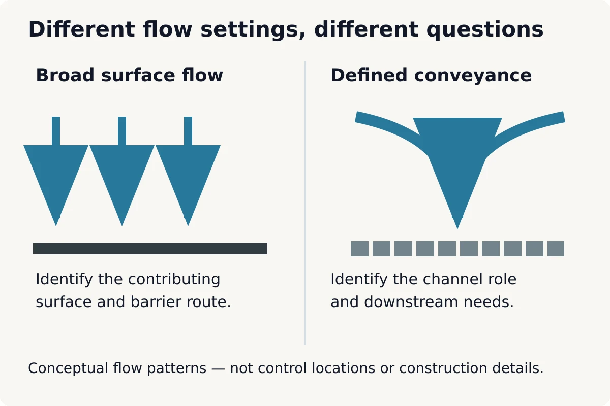
Rock check dam vs silt fence: compare design roles
A useful rock check dam vs silt fence comparison records the flow setting, intended function, limitation and next downstream question. This prevents the decision from becoming a product preference. It also makes it easier to identify when the available information does not support either option.
| Question | Rock flow check | Ordinary silt fence |
|---|---|---|
| Which setting is being discussed? | A designed temporary construction conveyance. | A location receiving sediment-bearing sheet flow. |
| What needs explanation? | The conveyance function and adjoining channel treatment. | The contributing surface and complete barrier alignment. |
| What should not be assumed? | Complete fine-sediment treatment or natural-channel suitability. | Suitability as a concentrated-flow check or dependable fine-particle filter. |
| What remains a design decision? | Selection, arrangement, associated protection and downstream measures. | Selection, location, support and coordination with other controls. |
This rock check dam vs silt fence table is a reading aid. It does not establish that a rock check is necessary wherever a channel appears, or that a fence is adequate wherever water looks shallow. The designer must consider the actual conditions, relevant criteria and consequences of the proposed arrangement.
It is also reasonable for a review to conclude that another measure or a revised drainage strategy is needed. A comparison article should not force the project into choosing between two options when neither has been demonstrated to fit.
Read the flow path before comparing rock check dams and silt fences
Begin with one area of proposed disturbance and follow its intended runoff route on the current construction-stage drawing. Identify where the route remains broad, where it gathers and where it leaves the area. Then locate the measures that correspond to those changes. This is a document-reading exercise, not a field instruction to alter drainage.
Next, compare that route with the timing of the work. A temporary swale may depend on land that will later be excavated or used for access. A receiving feature shown on the finished plan may not yet exist. The team should explain the arrangement for the stage when the control must function.
Finally, check whether the route ends at a meaningful destination. An arrow pointing beyond the drawing boundary can leave the most important question unanswered. Identify what the next feature is and who has established the requirements for it. Do not assume a storm sewer, neighbouring swale or natural feature is an authorized discharge destination.
Keep the permanent drainage design separate
A final grading plan explains the intended completed land levels and drainage relationships. It may provide important background, but construction can temporarily create different surfaces and routes. For that reason, the ESC designer and grading designer need consistent information about both conditions.
For example, a completed landscaped strip may eventually carry runoff, while the same area is bare and disturbed during an earlier stage. The team should not silently substitute the final condition for the temporary one. Likewise, a temporary control should not become a permanent drainage obstruction merely because nobody identified its removal stage.
Use Elmid Design Inc.’s broader ESC planning guide for the overall document process. This comparison focuses on the particular flow-setting question rather than repeating a general submission checklist.
Rock check dams and silt fences: recognize review triggers
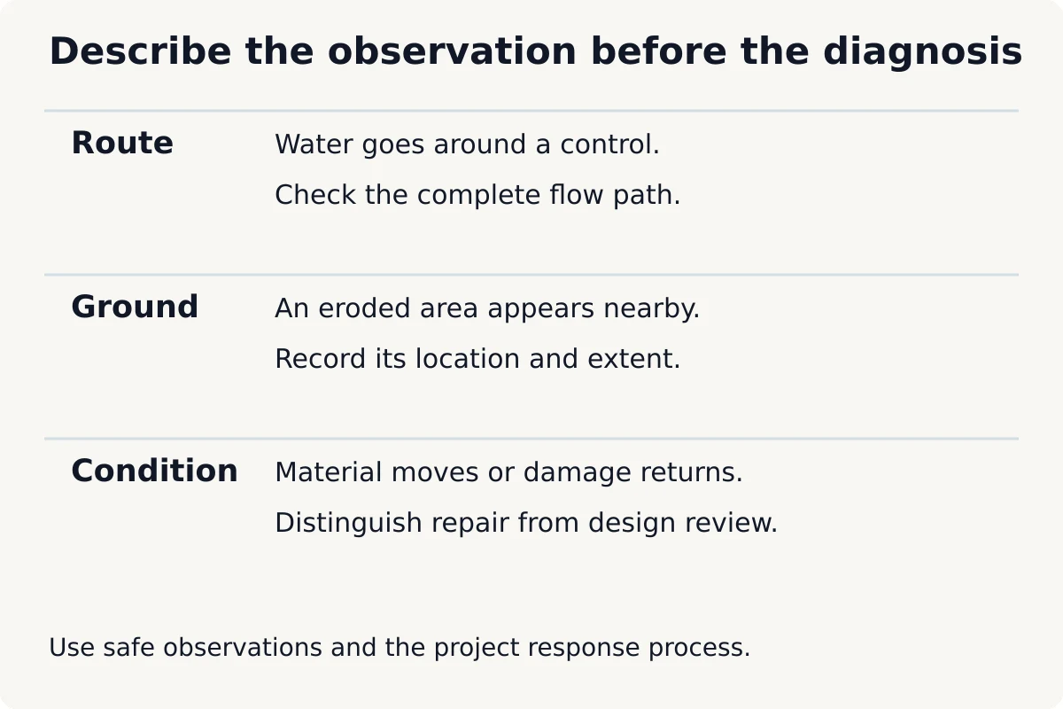
A photograph of a damaged control can show the symptom without establishing the cause. Record what is visible and where it occurred. Useful descriptions distinguish water going around an end, an eroded area beside a measure, displaced material and water occupying an unexpected part of the site.
Avoid turning those observations into an unsupported diagnosis. “There is an eroded route beside the control” is different from “the design is wrong.” The responsible reviewer may need the current drawing, the event timing and information about recent site changes before deciding what happened.
STEP’s rock-check appendix specifically calls attention to undermining and structural condition. The EPA background also discusses bypass and downstream scour. These references support the need to inspect the surrounding route, not only the central pile of stone. They do not authorize an owner to redesign the control from a photograph.
Maintenance and design review are not interchangeable
Routine maintenance restores the intended condition under the project arrangements. A design question asks whether that intended condition remains appropriate. The distinction matters when the same problem returns, when the contributing area changes or when site conditions differ from the assumptions used for the drawing.
The project should have a clear route for both. A maintenance record can identify the work completed, while a separate design response can identify a revised detail or arrangement where needed. Keep the two records connected so the next reviewer can understand whether the original condition was restored or deliberately changed.
If a condition presents an immediate environmental or safety concern, follow the project’s established response procedure and applicable reporting requirements. Do not enter flowing water, unstable ground or restricted work areas to obtain a better photograph. The responsible site team should manage observations and response safely.
Do not confuse clearer-looking water with demonstrated treatment
A visible deposit behind a control can show that some material accumulated there. It does not establish the quality of all water leaving the site. Similarly, water that looks less muddy is not automatically suitable for a particular receiving system or compliant with a permit condition.
For an owner, separate three records: the control’s observed physical condition, any monitoring required by the project, and the authority’s acceptance requirements. A photograph belongs in the first category unless a defined assessment gives it another role. Do not label it a water-quality test.
Ask who determines whether additional downstream treatment or specialist input is needed. The answer should relate to the actual receiving conditions and project requirements. A website comparison cannot establish a discharge criterion, treatment capacity or sampling programme for an unknown site.
Protect the source as well as the route
The presence of a flow check or fence should not remove the discussion about exposed ground. The wider ESC approach may include reducing unnecessary disturbance or protecting surfaces where appropriate. Those choices need coordination with the construction sequence rather than an assumption that downstream controls can compensate for any amount of exposed soil.
STEP’s ESC overview presents a multi-barrier approach. In practical owner terms, ask what prevents soil movement, what manages its route and what addresses sediment already carried by runoff. The answer may involve several coordinated measures. It should not depend on a single symbol doing every job.
Read rock check dam and silt fence symbols with the notes
A plan view shows where a measure is intended to be, but it may not explain the vertical relationship that matters. A symbol across a swale and a line beside a disturbed area can look similar at a small scale. Read the legend and referenced detail before deciding that the drawing calls for the same thing in both places.
The drawing package should distinguish a temporary control from a permanent drainage feature. It should also identify the construction stage to which a temporary arrangement applies. If a note describes one stage while the plan shows another, ask for clarification rather than combining the two into a new arrangement.
For an owner reviewing a quotation, this matters because a quantity of stone or length of fence is not the entire design. The referenced location, function and associated work explain what the item means. A material quantity without that context cannot establish whether a proposed substitution preserves the intended result.
Ask a question that the drawing can answer
Instead of asking, “Is this enough erosion control?”, identify a specific uncertainty. For example: “The temporary swale reaches this boundary, but the next receiving feature is not shown. Which drawing explains that connection?” A focused question gives the project team a clear subject to resolve.
Likewise, if a detail reference is missing, ask which detail belongs to the marked location. Do not choose a familiar detail from another project. The purpose of the clarification is to recover the designer’s intended arrangement, not to create a new one through informal interpretation.
Account for access to the control throughout its use
A temporary control can remain on a drawing after the site layout makes it difficult to reach. Stored materials, a new fence, a changed delivery route or a later construction stage may create that conflict. The owner should ask the construction team how it will fulfil its assigned inspection and maintenance responsibilities as the site develops.
This is not a request for the owner to specify equipment or working methods. It is a coordination question about whether the accepted arrangement remains practical. The contractor’s proposed access and methods may need review where they affect the control, protected areas or other project requirements.
Where access is restricted, distinguish a temporary inconvenience from an unresolved responsibility. If an area cannot be observed safely, the inspection record should state the limitation. It should not report that area as satisfactory merely because no defect was seen from elsewhere.
Plan the transition, not just the installation
Before the next stage begins, identify whether it changes the contributing area, removes access to a control or requires the temporary route to move. A stage transition can be significant even when the finished building layout stays the same. The relevant question is what the control must do during the transition itself.
Consider a hypothetical site where the temporary conveyance occupies the next work area. The plan needs an accepted sequence for that change; removing the control first and asking about the replacement later leaves the transition unresolved. The owner can help by ensuring that the contractor’s proposed sequence reaches the responsible designer in time for the required review.
Keep the resulting instruction specific. Identify the affected stage and drawing issue, who receives the direction and what remains to be confirmed. This avoids a common communication problem: a technically resolved question that never reaches the person using the earlier drawing.
Rock check dam vs silt fence: questions before substitution
A proposed substitution should identify the measure being replaced, its location and the reason for the request. “Equivalent product” is not enough information when the original and proposed measures may serve different hydraulic functions. Provide the current drawing reference and any relevant product information to the responsible reviewer.
Then ask what remains unchanged and what does not. Does the proposal assume the same arriving flow? Does it change the route, footprint or maintenance access? Will it affect another control? These questions help the reviewer understand the proposal without treating the owner’s preference as a technical approval.
Keep an accepted substitution with the drawing or direction that authorizes it. A supplier’s description, a contractor’s email and a consultant’s reviewed response have different purposes. The project team should know which record governs the arrangement actually used.
Compare the whole responsibility, not the purchase price
An owner comparing options should clarify which activities a quotation includes. Materials, installation, maintenance, repairs, removal and disposal may appear in different contracts or exclusions. A cheaper initial item does not establish that the full arrangement is suitable or that responsibilities have been covered.
This article does not provide installed prices or recommend a product. Instead, it helps the owner ask whether the quoted scope corresponds to the accepted design. Engineering/design fees should also be distinguished from the construction team’s physical work and from any separately agreed site review.
Document the rock check dam and silt fence comparison
A concise issue record is often more useful than a large collection of unlabelled photographs. Identify the affected control on the current plan, explain the observed or proposed change and provide the information needed to understand the flow setting. The record should describe the question without declaring an unsupported answer.
- Identify the drawing issue and affected location.
- State whether the concern is observed damage, a changed condition or a proposed substitution.
- Describe the route water appears to follow and any recent change in the contributing area.
- Attach dated photographs from safe locations and identify their viewpoints.
- Identify which party needs to review the question and who will communicate the response.
Separate confirmed facts from assumptions. If the team has not established whether an existing channel is artificial or regulated, say so. If the drawing no longer matches the site, show the difference. Accurate uncertainty is more useful than a confident label that sends the review in the wrong direction.
Close the record only when the required response and follow-up are clear. Issuing a photograph does not prove the issue is resolved. Likewise, issuing a revised drawing does not prove the site team has received or implemented it. Those are separate project actions.
Rock check dams and silt fences in conceptual situations
The following are hypothetical reading exercises, not completed projects or installation details. Elmid Design Inc. provides ESC engineering and civil-design coordination within an agreed scope. The deliverable may connect the temporary drainage information, selected controls and related drawings; it does not replace the contractor’s implementation responsibilities.
A broad work area develops a new low route
Imagine a perimeter fence shown for a particular work stage. Later, access traffic and grading changes create a more defined route toward one short section. The owner sees repeated damage there and asks for stronger fabric. That request may overlook the change in the arriving flow.
The useful next step is a focused review of the current route against the design basis. Supply the changed layout and observations. The review may distinguish maintenance from a need to reconsider the arrangement. The hypothetical situation does not establish that a rock check is the correct replacement.
A temporary swale reaches an unfinished receiving area
In a second example, the plan shows a temporary conveyance with a flow-interruption measure. The downstream area, however, will not be completed until a later stage. The owner asks whether the rock arrangement means the water can simply leave the work area.
The question is incomplete until the team explains the receiving arrangement for that stage. A control within the swale does not establish every downstream requirement. The design discussion must address the route beyond the measure and any separately required treatment or permission.
A channel is described only as an existing ditch
A third example begins with a photograph and a request to place stone across an “existing ditch.” There is no reliable description of its origin, connections or regulatory status. The first decision is not the stone size. It is whether the project team has enough information to understand the feature and applicable constraints.
This guide excludes natural water features. The owner should not use the comparison to authorize an obstruction while that status remains uncertain. Obtain the appropriate site and authority review before defining any work involving the channel.
Relevant Elmid Design Inc. experience and service scope
Elmid Design Inc.’s public project portfolio includes another project’s grading and drainage drawings for a proposed accessory building. The listed scope coordinated localized grading, a drainage swale, roof-water discharge and site-specific sediment fencing while retaining the wider drainage pattern. This is an example of coordinated design scope, not evidence of a rock-check installation or a particular approval outcome.
For a new assignment, Elmid Design Inc. reviews the proposed work and available civil information to define the agreed engineering deliverables. Its ESC design service can coordinate the plan with grading, drainage and site activities. Any construction-stage review must be expressly included in the assignment.
Send the current plans, project stage and the specific question about the proposed control arrangement. If the concern follows a site change, explain what changed and when. This allows the firm to assess the required design work without implying that an ordinary enquiry includes installation, continuous monitoring or specialist testing.
Frequently asked questions
Can a silt fence replace a rock check dam?
Not simply because both appear on an ESC plan. Their intended flow settings differ. Refer the proposed substitution to the responsible designer with its location and purpose; do not treat ordinary sediment fence as a concentrated-flow check.
Does every construction swale need rock check dams?
No universal answer follows from the word swale. Selection depends on the actual temporary conveyance, conditions and applicable criteria. The designer should explain the selected approach and its relationship to the rest of the ESC plan.
Will a rock check remove all fine sediment?
No such promise is supported. STEP identifies limited fine-particle settling for these temporary measures. Ask how the complete design addresses downstream treatment and receiving requirements rather than treating the flow check as a complete treatment system.
Can either measure be installed across a natural stream?
This construction-site comparison does not authorize work in natural water features. Do not install an improvised obstruction. Establish the feature’s status, required professional input and applicable permissions through the responsible project and authority process.
What if the fence looks intact but sediment appears downstream?
Record the location and conditions and refer the concern through the project’s inspection and response process. Appearance alone does not establish that the full system is functioning as intended. The relevant review may need information beyond the fence itself.
Does an ESC drawing include ongoing inspections by Elmid Design Inc.?
Not automatically. The consulting agreement must identify any construction-stage review. Installation, inspection, maintenance and reporting responsibilities should be clear in the project arrangements rather than assumed from the existence of a design drawing.
When can a temporary flow check or fence be removed?
Follow the accepted sequence, stabilization requirements and applicable approval conditions. Building completion alone is not a reliable removal instruction. The team should confirm the remaining drainage arrangement and the responsibilities for the transition.
Geographic Locations That We Service:
Elmid Design Inc. provides erosion and sediment control engineering and design consulting across Ontario service areas. The agreed scope depends on the property, proposed work and applicable review requirements.
We provide engineering services across a wide range of municipalities, each with its own requirements and review processes.
Toronto and Surrounding Areas
We provide engineering services in Toronto and provide grading engineering resources through our Toronto grading plan page.
Our service area also includes Oshawa, Pickering with our Pickering grading plan resources, and Clarington.
We also provide engineering services in Ajax through our Ajax grading plan resources, Whitby, Brock, Scugog, and Uxbridge, including our Uxbridge grading plan resources.
Halton Region
Within Halton Region, we provide engineering services in Burlington, including projects requiring Burlington grading plans.
We also provide engineering services in Halton Hills, supported by our Halton Hills grading plan resources.
Our service area also includes Milton and Oakville, including our Oakville grading plan resources.
Peel Region
Within Peel Region, we provide engineering services in Brampton, including projects requiring Brampton grading plans.
We also provide engineering services in Mississauga through our Mississauga grading plan resources and Caledon through our Caledon grading plan resources.
York Region
Within York Region, we provide engineering services in Vaughan and provide information about Vaughan grading plans.
We also provide engineering services in Aurora through our Aurora grading plan resources and East Gwillimbury through our East Gwillimbury grading plan resources.
Additional service areas include Georgina with our Georgina grading plan resources, Markham with our Markham grading plan resources, and Newmarket with our Newmarket grading plan resources.
We also provide engineering services in Richmond Hill with our Richmond Hill grading plan resources, Whitchurch-Stouffville through our Whitchurch-Stouffville grading plan resources, and King through our King grading plan resources.
Our service area also includes Bradford West Gwillimbury.
Other Southern Ontario Cities and Towns
We provide engineering services in many additional Southern Ontario communities, including Hamilton, St. Catharines, Niagara-on-the-Lake, Brant, Cambridge, Kitchener, Waterloo, and Woodstock.
We also provide engineering services in Guelph, Centre Wellington, Shelburne, Orangeville, New Tecumseth, Essa, Collingwood, Wasaga Beach, and Barrie, including our Barrie grading plan resources.
Additional service areas include Midland, Orillia with our Orillia grading plan resources, Ramara, Minden Hills, North Kawartha, Kawartha Lakes, Peterborough, Selwyn, and Brighton.