
Accessible Parking Grading Plan in Ontario
An accessible parking grading plan connects the parking space, access aisle and route to the building through coordinated elevations and drainage. Review accessible parking crossfall alongside access aisle drainage and the grading of the accessible route.
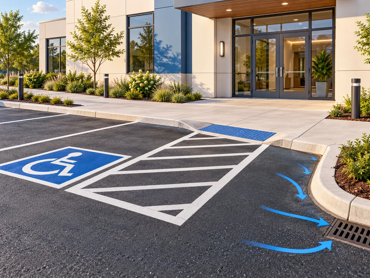
A painted symbol identifies a space, but it does not demonstrate that someone can leave a vehicle and reach an entrance. For an Ontario project, first establish the applicable accessibility, building and municipal requirements. Then test the complete route against the site information.
This guide explains the design questions an owner can bring to the project team. It focuses on grading and drainage coordination, not parking-demand calculations or a universal set of construction dimensions. Elmid Design Inc. provides engineering and design consulting within an agreed assignment. Installation, accessibility-specialist review and authority decisions remain separate responsibilities.
Key Takeaways
- Coordinate the complete parking-to-entrance route, not only the marked bay.
- Confirm project-specific accessibility criteria before choosing levels or surface details.
- Use verified survey information and reconcile the civil, building and site-plan interfaces.
Start the accessible parking grading plan with a complete route
Trace a continuous journey from the vehicle to the entrance before reviewing isolated slope labels. Identify the parking surface, transfer area, adjoining walkway, curb transition, any crossing and the entrance approach. The route may also need to connect with a payment machine or another feature that the intended users must reach.
At every connection, ask what changes in level, surface or direction. A parking bay might appear suitable while its access aisle ends against a curb. Alternatively, the aisle may reach a walkway whose fall changes abruptly at a drainage inlet. A plan should make these relationships visible rather than leave them for separate trades to interpret.
Use a marked route on the common site base. Give the relevant designer a consistent reference for proposed levels and transitions. If the building entrance changes during design, trace the route again. Its adequacy cannot be carried forward automatically from an earlier layout.
Also distinguish the pedestrian route from the route vehicles use. A line drawn across a drive aisle identifies an interface that needs coordinated review; it does not resolve visibility, traffic or pedestrian protection. Transportation and accessibility input may be needed alongside the grading design.
Requirements for an accessible parking grading plan
Ontario requirements come from more than one source. The Integrated Accessibility Standards Regulation addresses accessible off-street parking in its Design of Public Spaces provisions. Its application includes relevant new or redeveloped facilities that obligated organizations intend to maintain, with specified exceptions. Applicability should be assessed for the actual organization, facility and proposed work.
The Ontario Building Code accessibility overview describes requirements for most new construction and extensive building renovations. The building route and its entrance interface therefore need the responsible building designer’s attention. A civil drawing alone is not a complete building accessibility assessment.
Municipal standards, zoning and approval conditions may add project-specific requirements. Establish the applicable documents and their versions in a short design-basis record. When different documents appear to address the same feature, have the responsible professionals resolve the relationship. Choosing whichever value is easiest to achieve is not a sound coordination method.
Municipal guidance for accessible parking grading plans
The Toronto Accessibility Design Guidelines are a reference for accessibility audits and development planning. They do not become an Ontario-wide statutory parking specification simply because they contain useful diagrams. Confirm their application to a Toronto project and distinguish guidance from requirements imposed through the applicable approval framework.
Similarly, Mississauga’s Facility Accessibility Design Standards, version 2.0, state a scope involving newly constructed, renovated or leased municipal facilities. Do not apply that scope automatically to every privately owned parking lot in Mississauga. The project team should confirm the applicable municipal, building and accessibility requirements for the property.
This distinction matters before quoting a slope, width or clearance. A number without its source, feature definition and application can mislead the owner. The accessible parking grading plan should use verified project criteria rather than a collection of unrelated dimensions.
Survey inputs for an accessible parking grading plan
Reliable elevation information is the starting point for parking-to-entrance coordination. A layout traced from an aerial image cannot establish the surface levels needed for detailed design. Confirm which current survey and site records are available, what they cover and where additional information is needed.
Useful information includes the parking surface, curb edges, adjoining walkways, entrances, drainage structures and relevant surrounding grades. Record the survey date, elevation reference and limits of coverage. If the entrance is outside the survey area, identify that gap instead of treating its level as known.
Review the route as a surface, not only a series of widely separated points. Changes at pavement joints, curb returns or local depressions can matter even where the overall fall appears modest. The responsible designer should decide whether additional spot levels, sections or investigation are necessary.
Separate measured existing conditions from proposed design levels in both the legend and the drawing. Existing grades describe the site at the time of measurement. Proposed grades express the design intent. Confusing these two types of information can hide the actual amount and extent of the proposed change.
Reconcile existing records before filling survey gaps
Ask for the latest approved site plan, grading drawing, drainage report and relevant building drawings. Include subsequent amendments and available records of installed work. A record drawing and an approval drawing may serve different purposes, so label their status rather than treating every old drawing as equally authoritative.
For example, an earlier plan may show a drain that was relocated during construction. Current observations can reveal the difference, but its outlet and connection may still need verification. Avoid designing around an assumed underground arrangement simply because the surface cover is visible.
Where information conflicts, record the conflict and the person responsible for resolving it. A concise input register helps distinguish a confirmed entrance level from an owner estimate or an unverified historic note. This gives the team a defensible basis for proceeding with detailed grading.
Read accessible parking crossfall in the correct direction
Running slope and crossfall describe different directions. For a pedestrian route, running slope follows travel while crossfall acts across it. A surface arrow on a grading drawing may show drainage direction, but that arrow does not necessarily identify either direction for the person using the route.
Consequently, review the accessible parking crossfall together with the geometry of the bay, aisle and connecting path. A surface that falls gently in one direction can still have an unsuitable local transition in another. Corners, changes in pavement plane and the connections between surfaces deserve particular attention.
Ask the designer to identify the relevant slope directions and evaluation locations. Where the plan view is difficult to interpret, a section or enlarged detail can communicate the relationship more clearly. Keep the labels consistent across the site, grading and building documents.
The Toronto guideline’s off-street parking section distinguishes running slope, cross slope, surface openings and route connections. These are separate review subjects. Its numerical criteria should be used only with the appropriate jurisdictional and project context, not copied as universal Ontario limits.
Balance accessible parking crossfall with drainage criteria
Neither “make it flat” nor “increase the slope” is a complete design instruction. A surface needs a coordinated drainage strategy while meeting the applicable accessibility criteria. The designer must consider how water moves through the surrounding area and how the user moves across the same surface.
Making one small area flatter can create a low point at its edge. Raising that edge may then affect the adjoining walkway or entrance approach. Review the resulting surface and its connections rather than checking only the slope label within the parking rectangle.
Where site constraints make the preferred arrangement difficult, compare credible alternatives before fixing the layout. Relocating the space, changing a curb arrangement or revising the route may deserve review. Any required exception or alternative solution must follow the applicable process; a note on a drawing does not grant one.
Keep access aisle drainage usable
An access aisle supports movement between a vehicle and the adjoining route. It should not be treated as leftover pavement after parking spaces have been arranged. Show how the aisle connects to the pedestrian path and which levels control that connection.
Consider where runoff approaches the aisle and where it leaves. Water arriving from a larger parking area may cross the transfer area even when the aisle itself has a small contributing area. Review the upstream surface, not just the strip beside the vehicle.
Access aisle drainage also depends on local details. A depressed cover, pavement settlement or a curb edge can create an obstruction or ponding point. The design should identify the intended surface relationships, while construction verification and ongoing maintenance address the conditions actually delivered and retained.
Do not assume that a shared aisle resolves all layout questions. Confirm its applicable dimensions, markings, connections and use with the appropriate designers. Keep parking equipment, sign supports and other objects coordinated with the usable area rather than locating them from separate drawings without comparison.
Drainage collection in an accessible parking grading plan
Drainage structures need more than a convenient location on the storm servicing plan. Compare their surface positions with the accessible parking space, aisle, walkway and building approach. Review the cover or grate, surrounding grades, surface transitions and maintenance needs as a coordinated arrangement.
A drain beside the route can still affect it if surrounding pavement directs runoff across the travel area. Conversely, moving a drain to avoid a local conflict may require a different surface profile or servicing connection. The responsible engineer should assess those consequences before the revised location is adopted.
Where surface openings are relevant, consult the applicable accessibility criteria and product information. Opening geometry, orientation and surrounding levels are separate considerations. A generic grate symbol does not confirm that the specified product is suitable for the intended location.
Also distinguish routine drainage from the site’s larger stormwater strategy. The accessible parking grading plan should be coordinated with relevant ponding limits and overland flow information. A small local adjustment should not silently contradict the drainage assumptions used elsewhere in the submission.
Accessible parking grading design at the building entrance
The route often changes character between the parking surface and the building. It may meet a raised walkway, a depressed curb, an entrance landing or a doorway threshold. These interfaces need coordinated levels and details from the relevant civil and building designers.
A curb transition should connect to the intended path rather than simply face the nearest parking space. Examine the approach, change in direction and adjacent surface. If a person must turn at the transition, make that movement part of the review instead of assuming the route is a straight line.
At the entrance, compare the external approach with the building’s finished floor, threshold and door arrangement. The architectural or building drawings may include requirements that the grading sheet does not show. A shared reference to the entrance level helps prevent conflicting assumptions.
Do not solve an external drainage concern by changing a doorway detail without the building designer’s input. Likewise, a revised entrance level can affect the parking route and adjacent drainage. Changes should travel in both directions through the design team before the drawings are reissued.
Identify physical constraints at the entrance
Existing retaining walls, property boundaries, utilities and landscape features can limit the available grading options. Show the relevant constraints on the common base and identify which are fixed, which are proposed and which remain unverified.
Where a retaining wall forms part of the solution, distinguish its structural design from the surrounding surface grading. A wall line on a site plan does not establish its foundation, drainage or safety details. The relevant professionals should coordinate the wall, route and adjoining levels.
Neighbouring grades also matter. An accessible route improvement should not be assessed in isolation from the site’s drainage connections and boundaries. The project may require wider survey coverage or additional design coordination before the proposed levels can be established.
Compare accessible parking grading plan layouts
When an accessible parking grading plan encounters a difficult interface, compare options using the same information. A proposed location should not be selected only because it is nearest to the entrance. Consider its connection to the route, surrounding grades, drainage, physical constraints and the applicable layout requirements together.
Prepare a small option comparison that identifies the decisions still open. One option might retain the parking position but alter the walkway connection. Another might relocate the space and preserve more of the existing grading. Neither option is automatically preferable without examining the site and the relevant professional advice.
Compare the extent of affected work as well as the intended benefit. A relocated curb could change drainage boundaries, landscaping or a servicing access point. A different entrance route could affect building documentation or operational arrangements. These consequences should be visible before the owner commits to a particular scheme.
Separate a feasibility finding from a completed design. The team may identify a promising arrangement while still needing survey information or confirmation of the entrance interface. Record those dependencies so that a preliminary sketch is not presented as a finished accessible parking grading plan.
Use a feature-by-feature criteria record
A concise criteria record can identify the feature, applicable source, relevant requirement and responsible reviewer. Keep the parking bay, access aisle, walkway, curb transition and entrance as separate entries. This avoids assuming that a rule written for one feature governs all the others.
For each entry, distinguish dimensions from elevations and surface characteristics. A plan can reserve adequate space without resolving the proposed levels. Conversely, a grading arrangement may appear workable but conflict with the required clear area. Both questions need answers in the coordinated package.
Include the source date or version and any project-specific correspondence that explains applicability. If a requirement remains uncertain, name the decision needed rather than invent a criterion. The owner can then see why a particular confirmation is necessary before design proceeds.
Finally, carry the agreed basis into later reviews. When the layout changes, revisit the affected entries rather than assuming the earlier assessment remains valid. This keeps accessible route grading coordination tied to the actual current proposal.
Accessible parking grading plan: coordinate the drawing set
A coordinated drawing package lets a reviewer follow the same route across disciplines. The site plan establishes the layout, while the grading plan explains elevations and surface drainage. Building drawings address the entrance and relevant internal connections. Each document should agree on the shared interfaces.
Use consistent names for entrances, parking areas and key reference points. If one drawing calls an entrance “north entry” and another uses a different label, clarify the relationship. Small documentation differences can make a substantive design review harder than necessary.
For a complex interface, provide an enlarged plan or section where it helps communicate the design. Show enough surrounding information to explain the connection. A detail that omits the adjoining pavement or doorway level may look precise while leaving the central coordination issue unresolved.
The Mississauga grading-plan terms illustrate the importance of existing and proposed grades, entrance information, drainage patterns and relevant surrounding features. Those local submission expectations are not a replacement for the applicable accessibility assessment. They demonstrate why both kinds of information belong in a coordinated review.
- Site layout
- Identify the parking space, aisle, pedestrian route and entrance.
- Grading drawing
- Explain the relevant levels, surface relationships and drainage directions.
- Building information
- Confirm the entrance, threshold and internal interface with the responsible designer.
- Review record
- Record the applicable criteria, unresolved inputs and coordinated drawing issue.
Review proposed changes before calling them maintenance
Resurfacing, restriping and relocating a curb do not necessarily have the same design or approval implications. Describe the actual work and its effect on the parking arrangement, route and levels. Do not rely on a project label alone to decide which requirements apply.
Ontario’s accessibility compliance guide for industry distinguishes planned new or redeveloped public spaces from temporary unplanned changes and regular maintenance. The responsible team should assess the particular scope rather than assume that all paving work is either exempt or a complete redevelopment.
Compare the proposed work with the latest approved layout and current conditions. If spaces, aisles or routes move, trace the changed interfaces. Where an authority needs to confirm the application route, provide a clear description and marked comparison rather than a vague request about “parking improvements.”
Keep the approved arrangement separate from an early concept. An owner may use a sketch to discuss options, but that sketch should not be mistaken for an issued construction drawing. Clearly labelled design stages help the team manage decisions without implying permission to build.
Consider winter use and maintenance during design
Accessible route grading coordination continues beyond the initial drawing. Discuss how the owner intends to manage snow, surface repairs and drainage maintenance. The arrangement should be reviewed with its expected operation in mind, without treating operational promises as a substitute for suitable design.
Ask where snow will be stored and whether that area affects the route or drainage collection. A convenient storage location on an empty summer plan may occupy the aisle or direct meltwater toward an entrance. Identify the issue early so the owner and design team can consider a workable arrangement.
Similarly, think about how drainage structures and surface features will be reached for maintenance. Access should be considered without assuming that maintenance equipment can routinely occupy an accessible space or route. The appropriate operating arrangements depend on the site and the owner’s responsibilities.
Document who will retain the final drawings and maintenance information. If an inlet is later replaced or a surface patched, those records provide a basis for checking the change. A parking symbol can remain visible while the surrounding levels or clear route deteriorate.
A conceptual review of a revised entrance route
Consider an owner who wants to move accessible parking closer to a commercial entrance. The initial sketch shows a shorter route, but the existing pavement drains toward a low point beside the proposed aisle. The new position also meets an existing walkway at a different level.
The first useful step is to verify the relevant surface and entrance information. The team then compares the proposed parking location, aisle and walkway connection with the drainage arrangement. A shorter distance is one consideration, not proof that the revised route works.
Several design questions follow. Can the route connect within the applicable criteria? Does the local drainage collection need reconsideration? Would a change affect the building approach, adjacent parking or approved stormwater assumptions? The appropriate answer depends on the measured site and project requirements.
Elmid Design Inc.: accessible parking grading plan coordination
This is an illustrative coordination scenario, not a completed Elmid project or a construction detail. Elmid Design Inc.’s role in a comparable agreed assignment could include grading and drainage drawings and coordination with the relevant designers. It would not replace specialist accessibility advice or the authority’s review.
A verified example of broader civil coordination
Elmid’s public project portfolio records initial civil drawings and a stormwater report for a daycare addition in Richmond Hill. That work coordinated grading, storm servicing and drainage measures with the proposed building and parking layout. It illustrates the relationship between site systems, not a verified accessible-parking outcome.
The published record does not establish the accessible-space details or certify a completed route. Therefore, it should not be presented as a before-and-after accessibility case study. Its relevance here is the need to coordinate parking and building proposals with the civil design.
Issued design → appropriately scoped site observations → documented differences → responsible professional’s review. A drawing and a site observation describe different evidence; keep both identifiable.
Verify the installed grading against the design
An accessible parking grading plan describes proposed work; it is not evidence that the finished surface matches that proposal. Define the construction-stage review and verification responsibilities before work begins. The required process depends on the appointment, project and authority, so avoid assuming that design preparation includes unlimited site attendance.
Agree on which critical interfaces need confirmation and when they can be checked. A discrepancy discovered before final paving may be easier to evaluate than one found after surrounding work is complete. The contractor and responsible professionals should establish the appropriate sequence within their respective roles.
If actual site conditions differ from the drawings, refer the difference to the relevant designer. Record its location and provide suitable measurements and photographs. Do not independently raise an inlet, change a curb transition or alter the entrance approach simply to resolve one visible issue.
After an authorized revision, reconcile the affected documents. A changed surface level may require updates to the grading plan, site detail or building interface information. The final record should show what was reviewed and issued, rather than leaving the installer to choose between inconsistent sheets.
Keep measurements and observations distinct
A visual inspection can identify obvious obstructions, damaged surfaces or standing water. It does not establish every slope or elevation. Likewise, an isolated level measurement does not explain the entire route. Use the appropriate evidence for the question being reviewed.
Where a verification report or record drawing is required, identify its scope and limitations. State which areas were measured or observed and what remains outside that exercise. Avoid describing a limited grading check as a complete accessibility certification.
Keep the final drawing issue, relevant review correspondence and any documented changes together. The owner can then refer future repair or alteration questions to a coherent record. This is especially useful when the contractor, property manager or building occupant changes after completion.
Owner inputs for an accessible parking grading plan
Send the team the property location, proposed scope and available current survey. Include the latest site and building plans, drainage information and relevant approval correspondence. Explain which entrance the parking should serve and whether the proposal changes an existing arrangement.
Describe operational needs that affect the route, such as deliveries, snow storage, payment equipment or phased use of the property. Identify known problems without assuming their cause. Photographs of ponding or a difficult transition can help frame the question, but they do not replace the levels needed for design.
Ask the proposal to distinguish preparation of an accessible parking grading plan from other services. Confirm who addresses building accessibility, transportation, surveying and any required specialist assessment. Also establish how comments and revisions will be coordinated across the drawings.
- Confirm the design basis and applicable source documents.
- Identify missing survey, drainage and entrance information.
- Trace the complete parking-to-entrance route.
- Reconcile changed levels across the relevant drawing set.
- Define issue status, review responsibilities and construction-stage verification scope.
Finally, keep a dated record of unresolved decisions. A submission package should not disguise an assumed entrance level or an unconfirmed drain connection as settled information. Clear dependencies let the owner understand what remains before the next design issue.
Confirm the current drawing issue, applicable criteria and documented site observations. A proposed accessible route and its verified installed condition are different records.
Frequently Asked Questions
Does an accessible parking symbol prove that the grading is suitable?
No. The symbol identifies the intended parking use, but the surface, aisle and connecting route need separate assessment. Review the relevant elevations, transitions and drainage together with the applicable criteria. The building entrance interface also needs coordination with the responsible building designer.
Is there one Ontario slope rule for every accessible parking area?
Do not assume that one quoted slope applies to every feature and project. Establish the applicable legislation, municipal requirements and design guidance first. Then distinguish the parking surface, aisle, path, curb transition and entrance approach. The responsible professionals should document which criteria govern each part.
Can the access aisle be used to collect runoff?
That arrangement needs project-specific review rather than a general yes or no. Access aisle drainage must be coordinated with usability, surface openings and the surrounding grading. A low point or collection structure can affect the route even when the parking layout itself appears adequate.
Does repainting a lot require an accessible parking grading plan?
No universal answer follows from the word repainting. Explain whether the work changes the parking arrangement, usable route, surface levels or drainage. The project team and relevant authority can then identify the applicable review and documents. Do not describe a substantive layout change as routine maintenance without checking.
Can a Toronto accessibility diagram be used for another Ontario municipality?
It can help explain a design concept, but it is not automatic authority for another jurisdiction. Confirm the local requirements and the diagram’s intended application. A project-specific drawing must reflect the actual site and governing criteria, not simply reproduce a reference illustration.
Does Elmid Design Inc. install accessible parking or drainage works?
This article describes engineering and design consulting. Elmid Design Inc. can define an agreed grading and drainage documentation scope and coordinate relevant design interfaces. Construction, installation and maintenance remain separate services and responsibilities. Any additional professional review should be identified explicitly in the project appointment.
Geographic Locations That We Service:
Our Licensed Professional Engineers specializing in Engineered Site Grading Plans provide professional engineering and design services for site grading plans, lot grading, erosion and sediment control plans, and drainage plans to support applicable site plan approval and building permit applications in Ontario.
We provide engineering services across a wide range of municipalities, each with its own requirements and review processes.
Toronto and Surrounding Areas
We provide engineering services in Toronto and provide grading engineering resources through our Toronto grading plan page.
Our service area also includes Oshawa, Pickering with our Pickering grading plan resources, and Clarington.
Our engineering services also cover Ajax through our Ajax grading plan resources, Whitby, Brock, Scugog, and Uxbridge, including our Uxbridge grading plan resources.
Halton Region
Within Halton Region, we provide engineering services in Burlington, including projects requiring Burlington grading plans.
Our engineering services also cover Halton Hills, supported by our Halton Hills grading plan resources.
Our service area also includes Milton and Oakville, including our Oakville grading plan resources.
Peel Region
Within Peel Region, we provide engineering services in Brampton, including projects requiring Brampton grading plans.
Our engineering services also cover Mississauga through our Mississauga grading plan resources and Caledon through our Caledon grading plan resources.
York Region
Within York Region, we provide engineering services in Vaughan and provide information about Vaughan grading plans.
Our engineering services also cover Aurora through our Aurora grading plan resources and East Gwillimbury through our East Gwillimbury grading plan resources.
Additional service areas include Georgina with our Georgina grading plan resources, Markham with our Markham grading plan resources, and Newmarket with our Newmarket grading plan resources.
Our engineering services also cover Richmond Hill with our Richmond Hill grading plan resources, Whitchurch-Stouffville through our Whitchurch-Stouffville grading plan resources, and King through our King grading plan resources.
Our service area also includes Bradford West Gwillimbury.
Other Southern Ontario Cities and Towns
We provide engineering services in many additional Southern Ontario communities, including Hamilton, St. Catharines, Niagara-on-the-Lake, Brant, Cambridge, Kitchener, Waterloo, and Woodstock.
Our engineering services also cover Guelph, Centre Wellington, Shelburne, Orangeville, New Tecumseth, Essa, Collingwood, Wasaga Beach, and Barrie, including our Barrie grading plan resources.
Additional service areas include Midland, Orillia with our Orillia grading plan resources, Ramara, Minden Hills, North Kawartha, Kawartha Lakes, Peterborough, Selwyn, and Brighton.