Imported Fill Grading Plans in Ontario
Imported fill grading connects the receiving site’s purpose, placement limits and drainage design. This guide explains how owners can coordinate the grading envelope, specialist material assessments, staged work and closeout records without treating a drawing as permission to accept any soil.
What an imported fill grading plan should establish
An imported fill grading plan should explain why material is needed and where it can fit within a coordinated site design. A receiving site is not simply an empty area with room for trucks. Its proposed grades, drainage, property constraints and intended use must form a defensible design basis.
Start with the receiving property’s purpose, not with an offer of available soil. The receiving-site grading plan should establish the required finished landform and the limits of the placement area. Environmental and geotechnical suitability are separate questions that need the appropriate supporting professionals and evidence.
This guide focuses on receiving-site grading coordination in Ontario, with specific municipal examples from King and Oshawa. It is not a universal permit checklist or a legal determination under Ontario’s excess-soil rules. Requirements depend on the property, work, material and applicable authority review.
The aim is a package that connects the approved design intent to practical records. It should distinguish a planned elevation from an observed elevation, a design quantity from a delivery tally, and a suitable material assessment from a truck driver’s description. Those distinctions help an owner understand what remains unresolved before accepting fill.
Imported fill grading starts with a receiving purpose
A credible imported fill grading proposal starts with an actual land-use or grading objective. Describe the intended outcome in plain language. For example, the project may need a coordinated development platform, a permitted landscape profile or a correction to a documented grading problem.
Next, identify which parts of the site genuinely need a change in elevation. Do not assume the entire property can receive material. Existing drainage corridors, infrastructure, structures, access requirements and protected features may limit the workable area.
First, the design team should compare the proposed outcome with the existing site conditions. If the requested fill depth has no clear relationship to the final use, stop and clarify the purpose. A large available soil supply is not, on its own, a grading rationale.
Keep the receiving-site grading plan’s purpose statement consistent across the drawings and supporting documents. An application described as drainage improvement should not contain a landform that blocks the original outlet. Similarly, a temporary stockpile arrangement should not be presented as the permanent finished grade without the appropriate design and review.
Distinguish a receiving-site plan from a cut-and-fill estimate
A cut-and-fill estimate compares defined surfaces and reports quantities within stated boundaries. A receiving-site grading plan addresses the actual placement envelope, finished levels, interfaces and drainage consequences. The two can support each other, but they are not interchangeable deliverables.
A quantity calculation may show geometric space between two surfaces. It does not establish that every available material is suitable for that space. Nor does it settle environmental acceptance, permit requirements, access arrangements or field verification responsibilities.
For that reason, keep the quantity calculation’s assumptions visible. Link the calculation to the exact receiving-site grading plan revision and placement boundary. If either changes, revisit the quantity rather than continuing to quote an obsolete capacity figure as though it were an approval.
Existing conditions for imported fill grading
The imported fill grading design needs a reliable record of existing elevations and physical constraints. Identify the source and date of the topographic information. Confirm that it covers the proposed placement area and the features needed to understand drainage beyond it.
Old contours can be misleading if grading, stockpiling or construction has occurred since they were prepared. Ask the owner what has changed and arrange appropriate updated information. Do not combine several incompatible base drawings without explaining their relationship.
The surrounding conditions matter as well. A boundary elevation alone may not show where water currently travels or where it can safely continue. The receiving-site grading plan team should identify relevant neighbouring interfaces, existing outlets and known drainage infrastructure within its agreed scope.
Record limitations openly. If access prevented measurement of a critical feature, the plan should not imply that the feature was verified. Identify the missing information and its effect on the proposal. That allows the reviewer and owner to understand the actual level of certainty.
Keep legal limits and physical features distinct
A fence, vegetation line or visible edge of disturbance is not necessarily a property boundary. Use appropriate legal and survey information for the design. Similarly, an apparent ditch may have a function or ownership status that requires further confirmation.
Show easements and other relevant constraints from the available records, with their source. Do not assume a strip of land can receive fill simply because it appears unused. The imported fill grading design must account for the rights and infrastructure that affect the site.
If the owner proposes work close to a boundary, coordinate the existing and proposed interfaces carefully. A drawing should make the intended transition understandable. It should not imply permission to enter adjoining land or alter a neighbour’s property without the required arrangements.
Define the imported fill placement envelope
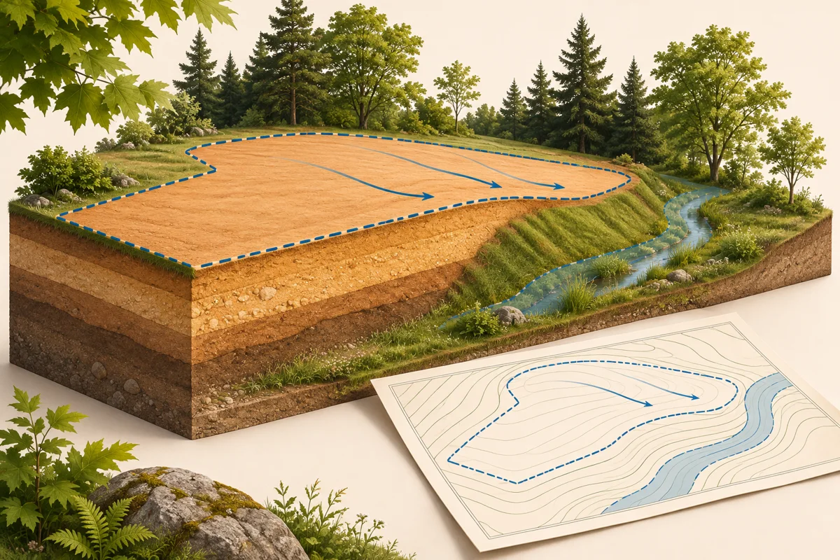
The placement envelope is the three-dimensional space where the proposed material would go. It includes a horizontal boundary and a vertical design basis. Both should relate to the intended finished condition and the applicable constraints.
On the receiving-site grading plan, identify the proposed receiving area clearly. Use sections where a plan view cannot explain the relationship between existing ground, proposed fill and adjacent features. Sections can be especially useful at grade transitions, drainage corridors and constrained edges.
Separate material layers where their roles differ. A structural fill zone, landscape layer and surface restoration layer may have different requirements. The responsible geotechnical and environmental professionals should define the relevant suitability criteria; the grading drawing should coordinate their spatial implications.
Do not treat an envelope as an invitation to fill every local depression. Some low areas may be part of a deliberate drainage route. The receiving-site grading plan must work as a connected system, not as a series of independent level surfaces selected only for convenience.
Imported fill grading and staged drainage
A final imported fill grading plan does not automatically describe safe interim drainage. During placement, stockpiles, temporary access and incomplete surfaces can change where water flows. The team should consider those stages rather than waiting for the final elevation to solve every problem.
Identify which existing drainage paths must remain functional and which proposed paths will replace them. The sequence should avoid creating a trapped area without an established outlet. Any temporary arrangement needs an appropriate design basis and coordination with the erosion and sediment control plan.
Distinguish clean off-site runoff from water affected by the active work area where the design requires that separation. The actual measures depend on site conditions and applicable review. Do not copy a generic detail and assume it fits the receiving site’s terrain or discharge constraints.
For the receiving-site grading plan, the owner should know who reviews significant changes during the work. If the contractor proposes a different sequence or temporary access route, that change may affect drainage. Bring it to the responsible designer rather than treating the approved final contours as blanket permission for any interim arrangement.
Check the interface with existing buildings and utilities
Raising surrounding grades can affect buildings, servicing and access. The receiving-site grading plan team should identify relevant thresholds, openings, utility features and drainage components. Their required relationships depend on the actual project and responsible specialist input.
Do not bury an existing feature because it is absent from an old drawing. If unexpected infrastructure appears, pause the affected placement and establish what it is. The resolution may require updated information or coordination with the owner of that infrastructure.
Similarly, a new grade beside a structure may create questions beyond surface drainage. Structural and geotechnical considerations can require separate professional review. A receiving-site grading plan should identify those interfaces without claiming to resolve work outside the agreed engineering scope.
Separate material quality from engineering suitability
Environmental quality and geotechnical suitability answer different questions. Material that satisfies one assessment may not satisfy the other. The receiving-site package should identify which professional is responsible for each conclusion and what evidence supports it.
For environmental matters, the appropriate qualified person should assess the applicable source and receiving-site information. For engineering performance, the geotechnical professional should address the material and placement requirements relevant to the intended use. Do not use a generic description such as clean fill as a substitute for either assessment.
The imported fill grading designer needs the resulting design constraints in a usable form. If a material is suitable only in certain areas or layers, show those limits clearly. If further testing or review is required before acceptance, preserve that hold point in the coordination records.
Owners should also distinguish a commercial agreement to supply soil from professional acceptance of that soil. A supplier’s availability, price or delivery schedule does not establish suitability. Resolve the evidence and responsibilities before treating the supply arrangement as part of the approved design basis.
Check the municipal route for the actual receiving property
Ontario municipalities can have different site alteration and fill processes. Check the current local requirements for the proposed work instead of borrowing a neighbouring municipality’s threshold. Other applicable permissions and professional obligations may also need consideration.
King publishes a site alteration and fill permit route and associated application guidance. Its development engineering material asks for existing and proposed site information, drainage and related design details, including fill quantities and quality information. These are local examples, not a province-wide submission standard.
Oshawa’s fill-operations guidance identifies a package that can include a work description, site plan, grading and erosion-control drawings, haul route and soils management information. Its published requirements also address supporting environmental documentation and receiving-owner consent. Confirm the actual application requirements with the responsible reviewer.
Keep the receiving-site grading plan’s regulatory check distinct from this general coordination guide. Current provincial excess-soil requirements and site-specific exemptions need assessment against the operative rules. Do not infer that a municipal permit removes other obligations or that one favourable assessment authorizes every part of the proposed work.
Record decisions rather than informal impressions
When the municipality provides direction, preserve the actual written response and the proposal it addressed. A general phone discussion may help identify the next step, but it should not become an invented approval statement on the drawing.
If the design changes, consider whether the earlier direction still applies. A different fill depth, footprint or intended use may raise different questions. Give the reviewer a clear description of the change rather than assuming the application address is enough to connect the old advice to the new proposal.
The owner’s project record should distinguish application submission, review comments and issued permission. These are separate stages. A complete-looking drawing set or a paid invoice does not establish that the receiving operation can begin.
Connect imported fill grading quantities to the design
Report quantities with a clear basis and stated limits. The reader should know which surfaces and areas were compared, which material layers are included and which exclusions apply. Keep the calculation linked to the current imported fill grading revision.
Delivery records may use a different measurement basis from the design calculation. Explain that difference before reconciling them. A truck count or loose-load estimate should not be treated as an exact measurement of compacted material in the final landform.
The design team should also account for uncertainty appropriately. An early estimate based on limited site information should not be marketed as a precise receiving capacity. Identify the information needed to refine it and the stage at which the figure will be updated.
If the proposed supply exceeds the design need, do not raise the site merely to accommodate the surplus. Revisit the receiving purpose and the approved envelope. The correct response may be to reduce or stop deliveries rather than change the landform without review.
Use a reconciliation record during the work
A useful reconciliation record connects the design quantity, incoming material records and observed placement progress. It should identify who maintains each part and how discrepancies will be investigated. This is a coordination tool, not a replacement for required regulatory records.
Compare like with like. If the delivery tally and field observation use different units or assumptions, explain them before drawing a conclusion. A difference may reflect measurement basis, incomplete placement, settlement assumptions or an actual error that needs investigation.
Do not force the records to match by editing historical entries without explanation. Preserve the original information and document any correction. A transparent discrepancy is easier to resolve than a neat spreadsheet that conceals how its figures were obtained.
- Grading plan
- Proposed landform and drainage
- Material evidence
- Environmental and geotechnical suitability
- Delivery records
- Incoming material information
- Field review
- Observed conditions within the agreed scope
Plan access without turning the grading drawing into a haul permit
Access affects the practical receiving arrangement. Identify the intended entrance, internal movement area and conflicts with drainage or protected features. Coordinate the relevant requirements with the authority and the responsible professionals.
However, a grading plan is not a haul-route approval or permission to alter a road entrance. Keep those responsibilities separate. Where a route or entrance needs additional review, show that dependency instead of implying the civil drawing settles it.
Consider how access changes as the fill area develops. A route that works at the start may be blocked by later placement. The receiving-site grading plan sequence should allow the necessary work without repeatedly crossing or damaging completed drainage features.
For imported fill grading, the owner should make the approved design information available to the people carrying out the work. A current drawing at the consultant’s office is not useful if the site team follows an earlier print. Establish an issue and communication process appropriate to the project.
Define hold points before accepting material
Hold points identify decisions that must be resolved before a particular activity proceeds. They are useful when environmental, geotechnical, municipal and civil information comes from different parties. The purpose is to prevent a missing input from becoming an irreversible site change.
Typical coordination questions include whether the source documentation has been reviewed, whether the proposed material matches the accepted basis and whether the receiving area is ready. The exact hold points must follow the project’s requirements and agreed responsibilities, not this general list alone.
Assign a named role to each decision. The truck driver, owner, contractor and consultant may have different responsibilities. Do not assume that one person’s presence on site means they can approve every technical or regulatory issue.
Provide a clear route for unexpected conditions. If material or site conditions differ from the accepted basis, the affected work needs appropriate review. Record the concern and contact the responsible professional rather than improvising a new acceptance rule at the gate.
Imported fill grading field review and closeout
Discuss field review and final documentation before construction starts. The scope should identify what the professional will observe, when review is needed and what records others must provide. A late request for a certificate cannot recreate observations that were never made.
The completed imported fill grading landform should be compared with the intended design using suitable information. Significant deviations need evaluation, not automatic acceptance. However, a final survey or measurement record is an input to that review; it does not, by itself, establish every aspect of material quality or construction compliance.
Keep environmental and geotechnical closeout records with the grading documentation where appropriate. Their purpose and author should remain clear. A civil drawing should not be used as a substitute for a specialist’s required conclusion.
Finally, the owner should understand any remaining limitations after closeout. For example, an assessment may address the reviewed grading work without warranting unrelated pre-existing conditions. Clear scope language protects the usefulness of the record and avoids overstating what the professional has verified.
Preserve the final design and actual-condition records
Retain the final receiving-site grading plan, relevant approvals, specialist reports, review records and documented changes. Organize them so a future owner or project team can distinguish proposed work from observed completed conditions.
Do not overwrite the history with a single undated drawing labelled final. If the work changed, record the change and the basis for acceptance. This helps explain why a completed feature differs from an earlier application drawing.
A good archive also supports future design decisions. If a later project needs to excavate, add a structure or alter drainage, the previous receiving-site information may be relevant. It should be available with its limitations rather than remembered through informal recollections.
Test the receiving-site proposal against practical changes
Before finalizing an imported fill grading package, ask how the design would respond to a change in supply, sequence or site information. This is not an invitation to redesign every possible scenario. It is a focused check of the assumptions most likely to affect the placement envelope and drainage arrangement.
For example, consider whether the receiving area can remain stable and drained if deliveries stop earlier than expected. An incomplete landform may need a planned interim condition. The responsible designers should identify the appropriate response rather than assume the final surface will always be reached without interruption.
Similarly, consider what happens if a proposed material source becomes unavailable. A replacement source needs its own applicable assessment. The grading drawing may remain useful, but it does not automatically approve a different material. Keep the design geometry and material-acceptance decision connected without treating them as the same thing.
Changes in access can also matter. If trucks must use another entrance or cross an area that was meant to remain undisturbed, review the affected arrangements. Do not allow an operational shortcut to become an unrecorded change to the approved receiving-site design.
Give the owner a clear decision record
The owner’s decision record should identify the current proposal, the professional inputs received and the remaining conditions. Keep it practical: what can proceed, what cannot yet proceed and who must resolve the next issue. Avoid broad statements that all engineering is complete when a specialist hold remains open.
Where the owner chooses between design options, explain the actual differences. One option may reduce the placement area but preserve an existing drainage corridor. Another may require additional investigation or review. Present those dependencies accurately without inventing cost savings or guaranteed approval times.
Record the selected option and the basis used at the time. If a later change introduces a different assumption, the team can then identify the affected decision. This is more reliable than relying on a meeting participant’s memory of an informal discussion.
Finally, make the current issued drawings easy to distinguish from superseded alternatives. A clear receiving-site grading plan issue register helps the site team use the intended design. It also protects the owner’s record by showing which information was available when each decision was made.
Elmid Design Inc.: receiving-site grading coordination
Within an agreed assignment, Elmid Design Inc. can prepare grading and drainage drawings that define proposed levels, placement boundaries and relevant site interfaces. The work can coordinate with environmental and geotechnical information supplied by the responsible specialists and address civil review comments.
The scope should state whether quantity calculations, erosion-control design, field review or closeout documentation are included. Those services should not be assumed from the phrase grading plan alone. Elmid Design Inc. provides engineering and design consulting, not soil supply, hauling, excavation or fill placement.
The public project portfolio demonstrates broader grading and servicing design work. It does not establish a completed imported-fill receiving operation for the scenarios below. These examples are therefore hypothetical coordination exercises, not client stories or evidence of a permit outcome.
Hypothetical example: the available supply exceeds the design need
Assume an owner has a proposed grading layout for a defined receiving area. A supplier offers more soil than the current design quantity. The owner asks whether the designer can simply increase the finished elevation to accept it.
The designer should first revisit the site’s purpose and constraints. Higher levels may change drainage, boundary transitions and building interfaces. The material supply does not establish that those changes are appropriate or permitted.
A responsible outcome may be to retain the original design and limit deliveries. If the owner wants a revised proposal, it needs the appropriate design assessment and review. The example shows why receiving capacity should follow the landform, not the other way around.
Hypothetical example: the delivery tally and site levels disagree
Assume the delivery records suggest that most of the planned quantity has arrived, yet the measured placement area remains below the intended surface. The team should investigate the measurement basis and actual placement before deciding what to do next.
The difference could involve the way loads were estimated, material placed outside the recorded area or other project-specific factors. The responsible professionals should assess the evidence rather than assume a single cause. Any required correction should preserve the original records and explain the change.
The lesson is not that delivery records are useless. They answer a different question from a landform measurement. Used together, with clear definitions, they can help the team identify a discrepancy that neither record would explain alone.
What to send for an imported fill grading review
Provide the property location, intended use and reason for importing fill. Include the available survey, proposed grading information, municipal correspondence and any environmental or geotechnical reports. Identify known easements, drainage concerns and relevant existing structures.
Explain whether soil has already arrived or work has already changed the site. That information affects the review basis and should not be hidden. If records are incomplete, list the gaps so the consultant can define the next useful step.
Also describe the service you need. A preliminary feasibility review, permit drawing package and final-condition assessment are different assignments. Clear expectations allow the consultant to identify the appropriate inputs and avoid promising a conclusion that the available evidence cannot support.
Frequently Asked Questions
Is an imported fill grading plan an approval to accept soil?
No. It documents the proposed grading design within its stated scope. Applicable permissions, material assessments and operational requirements remain separate. Confirm the actual receiving-site requirements before accepting deliveries or changing the landform.
Does clean-looking soil establish environmental suitability?
No. Appearance is not an adequate substitute for the applicable professional assessment and records. The appropriate environmental professional must address the source material and receiving-site requirements. Engineering suitability also needs separate consideration for the intended use.
Can truck counts replace the design quantity calculation?
No. Truck records and design quantities may use different measurement bases. Keep both records with their assumptions and reconcile them appropriately. Neither should be presented as a precise substitute for the other without a defensible basis.
Can the final grade be raised to receive extra material?
Only a properly assessed and, where required, reviewed design change can establish a different landform. Do not raise grades merely because surplus soil is available. Drainage, neighbouring interfaces, structures and other constraints still govern the proposal.
Does a municipal permit remove provincial excess-soil obligations?
Do not assume so. The project team must assess the applicable provincial and local requirements for the actual work. This guide does not determine exemptions or provide legal clearance for a receiving operation.
Can a final grading certificate be arranged after all work is complete?
The professional must determine whether the available evidence supports the requested statement. Missing observations or records may limit what can be confirmed. Discuss field review and closeout requirements before work begins rather than assuming certification is automatic.
Current authoritative references
Geographic Locations That We Service:
Our Licensed Professional Engineers specializing in Engineered Site Grading Plans provide professional engineering and design services for site grading plans, lot grading, erosion and sediment control plans, and drainage plans to support applicable site plan approval and building permit applications in Ontario.
We provide engineering services across a wide range of municipalities, each with its own requirements and review processes.
Toronto and Surrounding Areas
We provide engineering services in Toronto and provide grading engineering resources through our Toronto grading plan page.
Our service area also includes Oshawa, Pickering with our Pickering grading plan resources, and Clarington.
We also provide engineering services in Ajax through our Ajax grading plan resources, Whitby, Brock, Scugog, and Uxbridge, including our Uxbridge grading plan resources.
Halton Region
Within Halton Region, we provide engineering services in Burlington, including projects requiring Burlington grading plans.
We also provide engineering services in Halton Hills, supported by our Halton Hills grading plan resources.
Our service area also includes Milton and Oakville, including our Oakville grading plan resources.
Peel Region
Within Peel Region, we provide engineering services in Brampton, including projects requiring Brampton grading plans.
We also provide engineering services in Mississauga through our Mississauga grading plan resources and Caledon through our Caledon grading plan resources.
York Region
Within York Region, we provide engineering services in Vaughan and provide information about Vaughan grading plans.
We also provide engineering services in Aurora through our Aurora grading plan resources and East Gwillimbury through our East Gwillimbury grading plan resources.
Additional service areas include Georgina with our Georgina grading plan resources, Markham with our Markham grading plan resources, and Newmarket with our Newmarket grading plan resources.
We also provide engineering services in Richmond Hill with our Richmond Hill grading plan resources, Whitchurch-Stouffville through our Whitchurch-Stouffville grading plan resources, and King through our King grading plan resources.
Other Southern Ontario Cities and Towns
Our service area also includes Bradford West Gwillimbury.
We provide engineering services in many additional Southern Ontario communities, including Hamilton, St. Catharines, Niagara-on-the-Lake, Brant, Cambridge, Kitchener, Waterloo, and Woodstock.
We also provide engineering services in Guelph, Centre Wellington, Shelburne, Orangeville, New Tecumseth, Essa, Collingwood, Wasaga Beach, and Barrie, including our Barrie grading plan resources.
Additional service areas include Midland, Orillia with our Orillia grading plan resources, Ramara, Minden Hills, North Kawartha, Kawartha Lakes, Peterborough, Selwyn, and Brighton.