A well-designed grading plan Mount Forest plays a critical role in obtaining a building permit and setting the stage for long-term site stability. Builders, engineers, and property owners must follow the township’s grading rules to avoid drainage issues, erosion problems, or costly delays. In Mount Forest, part of Wellington North, grading plans are mandatory for both residential and commercial projects. These documents show how surface water will flow, how the land will be shaped, and how elevations will support safe construction. In this guide, you’ll learn how a proper grading plan keeps your project compliant, cost-effective, and build-ready from the start.
Key Takeaways
A grading plan in Mount Forest shows elevation details and stormwater direction
It’s mandatory for permits and reviewed by township engineering staff
The plan must align with building, zoning, and municipal servicing standards
Using a licensed engineer like Elmid Design Inc improves approval chances
Accurate grading prevents water damage, erosion, and future complaints
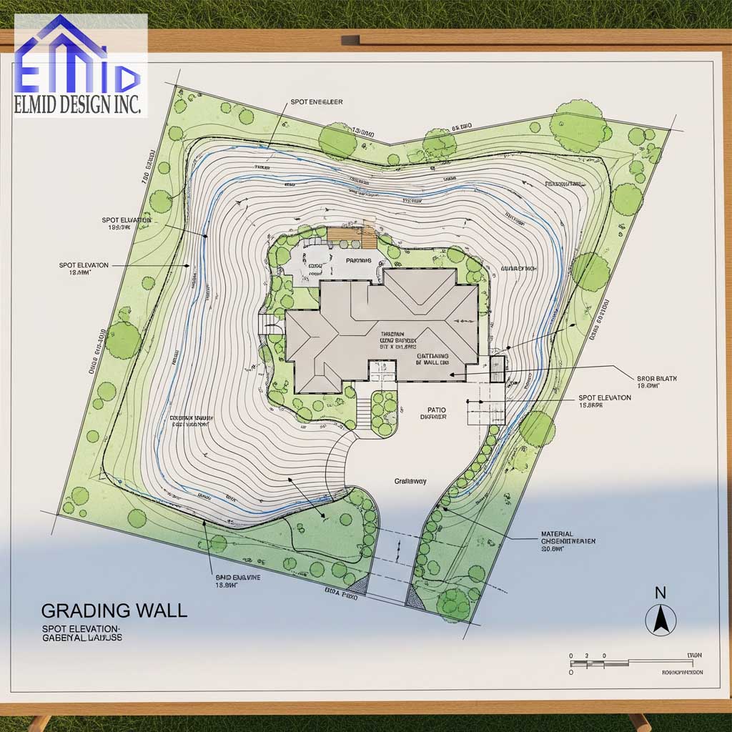
What a Grading Plan Mount Forest Includes
A typical grading plan Mount Forest includes detailed elevation data, slope directions, spot grades, and drainage paths. Engineers also show finished floor levels, swales, driveway grades, and setbacks. The goal is to manage runoff and maintain safe, buildable land. In Mount Forest, the plan must follow strict township requirements, including slope limits and lot boundary drainage protections. Grading plans are reviewed alongside the building permit application, and any errors can delay approval. Elmid Design Inc prepares these plans to match municipal templates, using CAD and GIS tools to provide clear and accurate grading data.
Why Mount Forest Projects Need Grading Plans
A grading plan Mount Forest isn’t just a technical drawing. It’s a legal and regulatory requirement for development. Without it, no excavation or building can start. The township uses these plans to confirm that your design won’t flood neighboring lots or interfere with infrastructure. Plans must match municipal servicing standards and reflect how the site will be drained. Failure to submit or follow this plan can result in permit rejection, penalties, or future drainage complaints. Elmid Design Inc ensures each grading plan meets the criteria of Wellington North’s building department and includes all critical engineering data.
Elevation and Slope Requirements
The Township of Wellington North requires that grading plans show both existing and proposed elevations. These are expressed as spot elevations and contour lines, clearly marked on the plan. Minimum slope percentages are required for driveways and side yards, often in the range of two percent to ensure water drains properly. A grading plan Mount Forest must direct runoff away from structures and into approved drainage routes, such as swales or stormwater systems. Elmid Design Inc ensures that all slope designs conform to township rules, helping reduce the risk of erosion, pooling, or failed inspections.
Drainage Strategy and Water Flow
A solid drainage strategy is one of the most important parts of a grading plan Mount Forest. Water must move away from foundations and toward controlled outlets. Drainage arrows, elevation grades, and swales are drawn to show how water will exit the property. Township staff examine these paths closely. If your site directs water to a neighbor’s property or a street without approval, the plan will be rejected. Elmid Design Inc designs drainage flow patterns that comply with municipal bylaws. Their grading plans help property owners avoid water-related complaints and meet stormwater management standards.
The Role of a Professional Engineer
Only a licensed engineer can prepare a grading plan Mount Forest that meets PEO standards. The Township of Wellington North requires engineered plans for most residential developments. These must be signed and sealed by a PEO-authorized professional. The engineer ensures compliance with building codes, soil conditions, and hydrological impact. Elmid Design Inc holds a certificate of authorization from PEO and provides sealed grading plans for municipal submission. Their expertise ensures that all technical standards are met and that the township’s engineering department can approve the plan without delays or revisions.
Permit Application Process in Mount Forest
Before breaking ground, property owners must submit a grading plan Mount Forest with their building permit application. This submission goes to the Wellington North Building Department, which checks it for accuracy, compliance, and drainage performance. The plan must align with zoning standards, site servicing, and construction footprints. Any mismatches between the plan and site drawings lead to delays or rejection. Elmid Design Inc carefully reviews each grading plan to match municipal checklists. Their attention to detail increases the chance of first-time approval and reduces costly plan resubmissions or redesigns.
Grading Challenges in Mount Forest Terrain
Mount Forest features a mix of urban infill, rural lots, and sloped land, all of which present unique grading challenges. A grading plan Mount Forest must account for natural slopes, high water tables, and existing infrastructure. In older neighborhoods, lot grading must match elevations on adjacent properties to avoid drainage conflicts. On rural properties, culverts and ditch systems often need integration into the design. Elmid Design Inc uses site surveys and elevation data to develop accurate plans that adjust to the specific topography of each lot in Mount Forest, reducing errors in slope or flow calculations.
Importance of Matching Site Servicing Plans
Grading plans must align with servicing plans that show water, sewer, and storm infrastructure. A grading plan Mount Forest that conflicts with these systems can lead to construction issues and permit rejection. Proper elevation grading ensures water flows into catch basins, not away from them. Likewise, swales must not block access to underground services. Elmid Design Inc coordinates their grading plans with site servicing layouts to ensure a unified design. Their integrated approach supports faster approvals, fewer construction problems, and smooth site inspections throughout the build.
Retaining Walls and Grading Limits
In some developments, retaining walls are required to handle elevation changes. A grading plan Mount Forest must show the location, height, and drainage features of any proposed retaining walls. The Township of Wellington North reviews these carefully to ensure walls don’t increase runoff to nearby lots or affect foundation safety. Poorly designed retaining walls lead to structural issues or rejected plans. Elmid Design Inc designs walls in tandem with site grading, including all structural and flow details. Their engineered approach helps pass reviews while avoiding post-construction drainage problems.
Grading Plans for Subdivision Development
Larger subdivisions in Mount Forest require coordinated grading plans for multiple lots. These plans must show how individual lots will drain while also linking to a broader stormwater management strategy. A grading plan Mount Forest for subdivisions includes road slopes, lot swales, common drainage areas, and flow directions for catch basins. Township engineers evaluate each lot for compliance and demand clear elevation transitions from one property to the next. Errors in these plans can create pooling, boundary disputes, or rejected submissions. Elmid Design Inc develops comprehensive subdivision grading packages that ensure smooth review and consistent drainage outcomes across all lots.
How to Read a Grading Plan in Mount Forest
Understanding the elements of a grading plan Mount Forest helps builders and homeowners stay compliant during construction. These plans include contour lines showing changes in elevation, spot grades for building entrances, and slope percentages for hard surfaces. Drainage arrows indicate water flow, while shaded areas may represent cut or fill zones. Reading these features correctly ensures that site excavation and backfilling align with the approved design. Contractors who misread the plan risk violating slope requirements or redirecting drainage incorrectly. Elmid Design Inc creates plans that are not only accurate but also easy to interpret for on-site work.
Elevation Errors and Consequences
Elevation mistakes in a grading plan Mount Forest can lead to serious construction problems. Building too low may cause water to collect near the foundation, while building too high can create runoff toward neighboring lots. These errors often occur when engineers or contractors skip proper site surveys or ignore municipal elevation requirements. Incorrect elevations result in failed inspections, rework costs, and delays in closing permits. Elmid Design Inc uses precise digital surveys and topographic data to eliminate guesswork. Their grading plans undergo internal reviews to ensure elevation data matches real field conditions before submission.
Final Inspection and Compliance Check
After construction, the township conducts a final inspection to verify that the work follows the approved grading plan Mount Forest. Inspectors check drainage patterns, slope gradients, and finished elevations to confirm alignment with the original drawings. If discrepancies are found, the site may require regrading or additional engineering input before occupancy can proceed. Property owners who skip this step risk permit issues and liability for drainage problems. Elmid Design Inc offers site supervision and final grading verification to ensure the project passes inspection without delays. Their follow-through improves project timelines and keeps documentation up to code.
Common Issues that Delay Approvals
Several recurring issues cause grading plans in Mount Forest to be delayed or rejected. These include missing spot elevations, unclear drainage paths, incorrect slope values, and inconsistencies with servicing plans. Plans that lack a professional engineer’s seal also fail instantly. Poorly labeled features or incomplete annotations confuse reviewers and slow the process. Township officials expect clean, accurate, and fully labeled documents. Elmid Design Inc avoids these pitfalls by following municipal templates and checklists. Their plans undergo quality assurance before submission to ensure approval conditions are met on the first review without unnecessary revisions.
Climate and Soil Impact on Grading
Mount Forest’s local soil conditions and climate must be considered when designing a grading plan. The region experiences freeze-thaw cycles, high precipitation in spring, and heavy snow accumulation in winter. These factors increase the risk of erosion, shifting soil, and blocked drainage if the grading is not planned properly. A grading plan Mount Forest must reflect these seasonal challenges. Engineers must also account for soil permeability, compaction, and vegetation when planning drainage. Elmid Design Inc adapts each design to site-specific conditions using climate data and soil reports. This ensures each grading plan supports long-term site stability year-round.
Grading for Access and Mobility
Grading impacts more than drainage and elevations. It also affects how people and vehicles access the property. A grading plan Mount Forest must ensure that driveway slopes do not exceed township limits and that walkways remain accessible. Poor grading can create steep entrances, dangerous footing in winter, or inaccessible steps. Municipal rules often mandate slope percentages for driveways and require smooth transitions at curb cuts. Elmid Design Inc considers access early in the grading design process. Their engineered plans balance drainage control with mobility, improving comfort and safety for homeowners and visitors after construction.
Legal Risk of Improper Grading
Improper grading can lead to more than just permit issues. It can cause legal conflicts with neighbors, especially when runoff damages adjoining properties. A grading plan Mount Forest must demonstrate that stormwater will remain within the lot or flow into approved infrastructure. If a plan fails to show this, the township may deny the permit, or worse, property owners may face legal action. Insurance claims, lawsuits, and repair costs can follow. Elmid Design Inc prevents these outcomes by designing every plan to meet both engineering standards and legal expectations, giving property owners peace of mind throughout the process.
Green Infrastructure in Grading Designs
Modern grading plans increasingly include green infrastructure to manage water naturally. A grading plan Mount Forest can incorporate bioswales, permeable surfaces, or vegetated buffers to slow runoff and improve filtration. These features help reduce the load on municipal stormwater systems while enhancing landscape resilience. Mount Forest’s development guidelines support sustainable options when integrated with drainage control. However, proper grading must still meet slope and flow requirements. Elmid Design Inc includes green elements only where they meet code and function within the overall grading scheme. Their designs balance environmental value with engineering compliance and permit-readiness.
Elmid Design Inc’s Role in Mount Forest Grading
Elmid Design Inc serves Mount Forest builders and homeowners by providing grading plans that pass inspections and align with municipal standards. As a PEO-authorized firm, they deliver professionally sealed documents that meet the expectations of Wellington North’s planning and engineering departments. Their team uses advanced CAD tools, accurate survey data, and regulatory knowledge to complete each plan quickly and correctly. Elmid Design Inc understands the challenges of grading in Mount Forest and customizes every plan based on site terrain, drainage demands, and zoning codes. This expertise helps clients build with confidence, knowing their site grading meets every legal and engineering requirement.
Integrating Landscaping with Grading
Landscaping decisions must align with the grading plan to avoid long-term problems. A grading plan Mount Forest must anticipate where gardens, sod, or hardscapes will go. Adding a patio or planting beds without respecting slope directions often leads to pooling or erosion. Elevation changes created by retaining walls, mounds, or decorative features need coordination with drainage paths. Elmid Design Inc advises clients on grading-friendly landscaping choices and integrates these into the engineered plan. This forward-thinking approach helps ensure that both the visual and functional goals of the site are met without compromising on drainage or accessibility.
Grading Plan Updates After Construction Begins
Site conditions often change after excavation begins, which sometimes requires grading plan updates. A grading plan Mount Forest must reflect accurate, real-time conditions if slopes or elevations shift during construction. Township inspectors compare the final grade to the approved plan, and any deviation may require a revision. Failing to update the plan causes rework, delays, or permit issues. Elmid Design Inc remains available during construction to review site changes and issue updated drawings when necessary. Their responsive service helps builders stay compliant and avoid issues during final inspections or occupancy applications.
How Mount Forest Handles Lot-Specific Plans
In infill or irregular lots, Mount Forest requires customized grading plans rather than standard templates. A grading plan Mount Forest must address unique lot features like narrow widths, awkward slopes, or unusual access points. Standard municipal designs often fail to capture these needs. Elmid Design Inc builds custom grading solutions for each property. Their plans reflect the real terrain, surrounding conditions, and zoning nuances that define Mount Forest development. This tailored approach speeds approval by avoiding template mismatches and ensures safe, legal drainage design for even the most complex sites.
Coordination with Surveyors and Contractors
Grading plans do not stand alone. They must coordinate closely with survey data and construction activity on the ground. A grading plan Mount Forest is only effective when it matches staked elevations and built structures. Misalignment between the plan and fieldwork leads to inspection failures and drainage errors. Elmid Design Inc works directly with land surveyors and construction teams to ensure that field layout matches the engineered drawings. This coordination reduces communication gaps and improves on-site accuracy. By staying engaged throughout the project, they protect grading integrity and maintain full compliance with municipal expectations.
How Grading Plans Protect Property Value
A well-executed grading plan protects more than just the structure. It also safeguards long-term property value. A grading plan Mount Forest that manages water properly preserves foundations, prevents erosion, and supports landscaping longevity. Buyers and inspectors look for these qualities when assessing property risks. Poor drainage lowers real estate appeal and introduces hidden repair costs. Elmid Design Inc delivers grading plans that meet municipal approval and build lasting value. Their plans help developers, builders, and homeowners achieve not only permit success but also future-proof investments across Mount Forest real estate markets.
Frequently Asked Questions (FAQ)
What is a grading plan Mount Forest?
It is a detailed engineering drawing that shows how the land around a structure will be shaped to control drainage, set elevations, and meet building regulations in Mount Forest.
Do I need a grading plan for a single house?
Yes. In Mount Forest, even single-detached residential builds require a grading plan approved by the township before receiving a building permit.
Who can create a grading plan in Mount Forest?
Only a licensed professional engineer can create a compliant grading plan for municipal review. The engineer must also seal and sign the document.
How long does it take to get a grading plan approved?
The township generally reviews grading plans within two to three weeks, depending on complexity and whether the documents are complete on first submission.
What happens if my final grade doesn’t match the plan?
You may be required to regrade the site or submit a revised plan. Approval for occupancy could be delayed until the township confirms compliance.
Can Elmid Design Inc handle Mount Forest grading plans?
Yes. Elmid Design Inc specializes in preparing grading plans that meet Wellington North’s requirements. Their team holds PEO authorization and provides sealed engineering drawings for all types of properties.

Trusted Grading Plan Experts in Mount Forest: Elmid Design Inc
Elmid Design Inc delivers professionally engineered grading plans in Mount Forest that meet township standards and pass inspections. As a PEO-authorized firm, their team designs every plan with precision, using advanced tools and local compliance knowledge to support fast permit approvals. Known for accuracy, responsiveness, and expert coordination with builders and surveyors, Elmid Design Inc helps ensure safe, buildable sites from start to finish.
Geographic Locations That We Service:
Our Licensed Professional Engineers specializing in Engineered Site Grading Plans offer the best-engineered site grading plan, lot grading and erosion plan, and drainage plan to obtain site plan approval and building permits in Ontario, including a wide range of municipalities. Each area boasts unique features and requirements, making our tailored approach essential for success.
Toronto and Surrounding Areas
In the vibrant heart of Ontario, we service Toronto (City of Toronto) and surrounding areas. Additionally, we cover Oshawa (City of Oshawa), Pickering (City of Pickering), and Clarington (Municipality of Clarington). Furthermore, our expertise extends to Ajax (Town of Ajax), Whitby (Town of Whitby), Brock (Township of Brock), Scugog (Township of Scugog), and Uxbridge (Township of Uxbridge).
Halton Region
Moving to the Halton Region, our services encompass Burlington (City of Burlington) and Halton Hills (Town of Halton Hills). Also included are Milton (Town of Milton) and Oakville (Town of Oakville).
Peel Region
In the Peel Region, we provide services in Brampton (City of Brampton), Mississauga (City of Mississauga), and Caledon (Town of Caledon).
York Region
Our services in the York Region cover Vaughan (City of Vaughan), Aurora (Town of Aurora), and East Gwillimbury (Town of East Gwillimbury). We also cater to Georgina (Town of Georgina), Markham (City of Markham), Newmarket (Town of Newmarket), Richmond Hill (City of Richmond Hill), Whitchurch-Stouffville (Town of Whitchurch-Stouffville), King (Township of King), and Bradford-West Gwillimbury (Town of Bradford-West Gwillimbury). Each municipality here offers a distinct setting, requiring our specialized approach.
Other Southern Ontario Cities and Towns
We also serve many other cities and towns in Southern Ontario. These include Hamilton (City of Hamilton), St. Catharines (City of St. Catharines), Niagara on the Lake (Town of Niagara on the Lake), Brant (County of Brant), Cambridge (City of Cambridge), Kitchener (City of Kitchener), Waterloo (City of Waterloo), and Woodstock (City of Woodstock). Furthermore, we operate in Guelph (City of Guelph), Centre Wellington (Township of Centre Wellington), Shelburne (Town of Shelburne), Orangeville (Town of Orangeville), New Tecumseth (Town of New Tecumseth), Essa (Town of Essa), Collingwood (Town of Collingwood), Wasaga Beach (Town of Wasaga Beach), Barrie (City of Barrie), Midland (Town of Midland), Orillia (City of Orillia), Ramara (Town of Ramara), Minden Hills (Town of Minden Hills), North Kawartha (Town of North Kawartha), Kawartha Lakes (City of Kawartha Lakes), Peterborough (City of Peterborough), Selwyn (Town of Selwyn), and Brighton (Municipality of Brighton).