A grading plan Erin serves as a detailed guide showing how land is shaped, sloped, and directed to manage drainage, erosion, and development. It plays a critical role in preparing construction sites or residential developments in Erin and connects municipal compliance with engineering precision. This article explores how to create a grading plan Erin that meets technical standards and delivers practical results.
What Is a Grading Plan Erin and Why It Matters
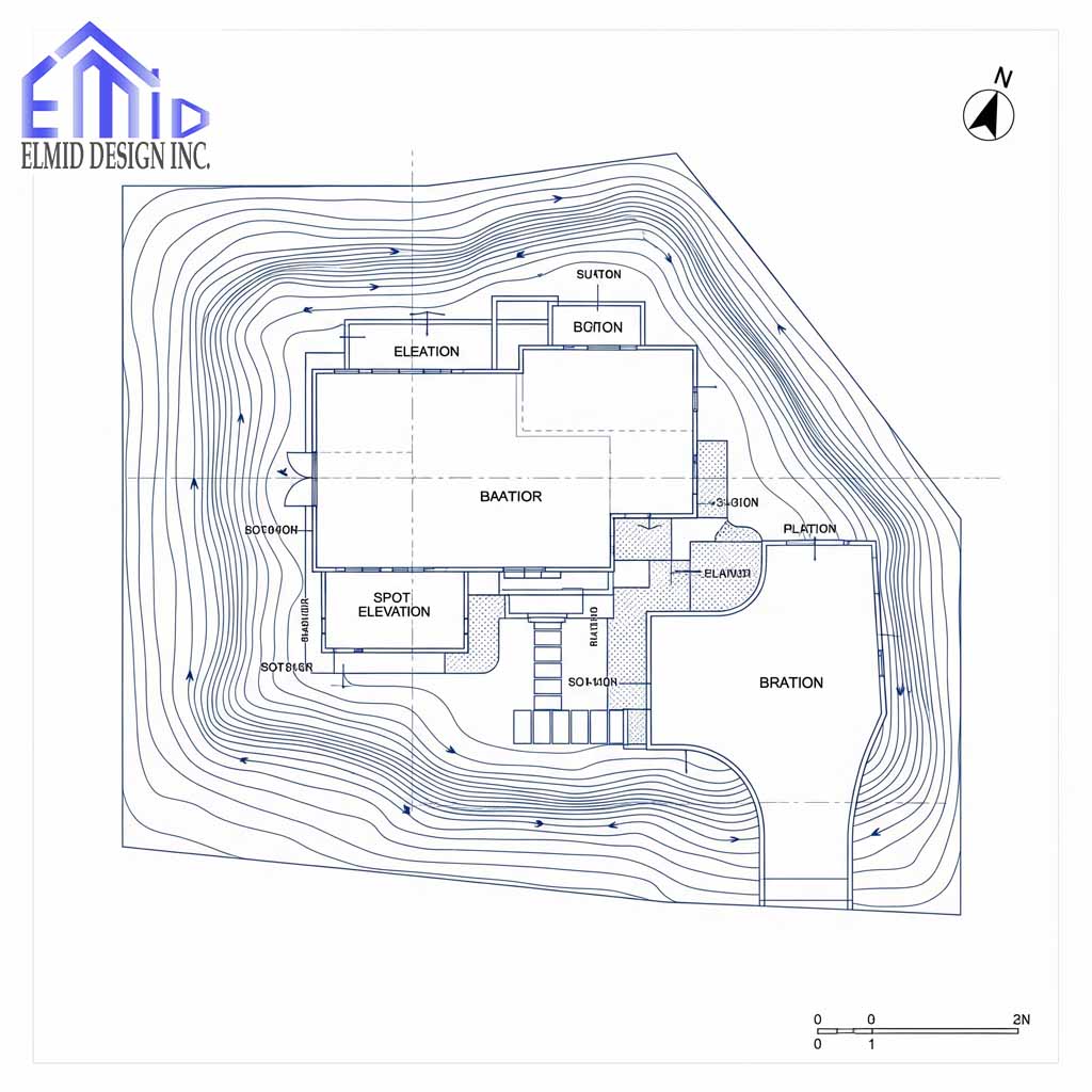
A grading plan Erin defines how surfaces slope away from structures and toward drainage systems to prevent surface water issues and facilitate construction. It illustrates existing and proposed contours, elevations, drainage routes, and overland flow directions. The town of Erin’s design standards stress locating building envelopes, swales, catchbasins, and retaining walls using lots, blocks, and easements. Arrows must show surface run-off from all lots, swales must include percent grade and invert elevations, and elevations at grade change points must be mapped carefully. These elements ensure effective drainage and protect surrounding properties and natural habitats.
Key Elements Found in a Grading Plan Erin
Every grading plan Erin includes key components such as existing and proposed elevations at corners, building envelopes, and intermediate grade points. The plan must depict drainage structures, overland flow routes, and swales with elevations and slopes. Profiles of roads and utilities with precise elevations and stationing ensure clarity. Erosion and sediment control also feature prominently, and the plan must include utility plans, composite service layouts, and grading master plans for parks. Town standards ensure these details are consistently integrated into development reviews.
How Erin’s Engineering Standards Shape Grading Plans
Erin’s engineering design standards require grading plans to include topographic detail, precise elevation data, direction of surface runoff, swales with invert elevations, catchbasins, and escarpments. Plan–profile drawings must use horizontal and vertical scales and include utilities, curbs, gutters, and roadway profiles. Parkland development demands master plans displaying drainage, contours, water structures, and plant species and sizes. These rigorous requirements establish consistency and technical reliability in grading plan Erin documentation.
Creating a Grading Plan Erin That Meets Regulatory Requirements
Creating a grading plan Erin that satisfies municipal standards involves capturing existing conditions, accurately plotting elevations for corners and building envelopes, and marking swales and drainage. Surface run-off direction must be clearly indicated. Catchbasins, retaining walls, fencing, and easements require notation. The plan must use plan–profile drawings to ensure road and service elevations are precise. Erosion control measures and parkland grading master plans, if applicable, must be included. Applying Erin’s design standards enhances plan approval and supports erosion control and site safety.
Professional Oversight and Legal Compliance for Grading Plan Erin
The creation of a grading plan Erin must involve a licensed professional engineer or surveyor to ensure technical accuracy and legal compliance. Plans must be sealed with professional credentials. Municipalities may require approval from conservation authorities, especially when developments impact natural heritage systems or buffer zones. Professional supervision ensures plans reflect proper drainage, erosion control, and site grading while aligning with environmental regulations and local development guidelines.

Engineering Review and Municipal Approvals in Erin
Once a grading plan Erin is completed, it must be submitted for review by the Town of Erin’s engineering department. This step ensures the proposed site grading complies with municipal guidelines, aligns with stormwater management practices, and supports overall site development. The review process involves careful checks for accurate drainage direction, adequate swale slopes, and clear overland flow routes. Plans that fail to meet the minimum percent grade or omit necessary detail will be rejected. Review staff examine every elevation, contour, and cross-section to verify conformity. Engineers may request revisions to ensure designs respect natural features, avoid negative impact on adjacent properties, and meet utility service connection standards. Applicants must revise and resubmit if corrections are required, with timelines dependent on the complexity of the project and accuracy of the original submission. Without this stage, a project cannot proceed to permit issuance or construction.
Grading Plan Erin and the Role of Elmid Design Inc
Elmid Design Inc plays a crucial role in delivering certified and accurate grading plan Erin documents across residential, commercial, and institutional developments. As a firm authorized by the Professional Engineers Ontario (PEO), Elmid Design Inc ensures each grading plan aligns with Erin’s engineering standards. Their team verifies grading compatibility with topography, infrastructure, and hydrology, enabling precise elevations and run-off control. By including swale slopes, catchbasin locations, and driveway gradients, they prevent flooding, erosion, and costly drainage failures. Their sealed engineering drawings add credibility and help fast-track municipal approvals. Their field experience ensures grading designs reflect real-world conditions, not just CAD-based models. Clients benefit from coordinated design, reliable project management, and full compliance with the Town of Erin’s grading, roadworks, and stormwater guidelines. This combination of engineering certification and practical oversight strengthens the credibility of development applications and reduces design deficiencies that often delay site permits or construction.
Common Mistakes That Delay Grading Plan Approval in Erin
Errors in grading plan Erin submissions can stall the approval process, create compliance issues, or result in failed inspections. The most common mistake is failing to show clear surface runoff direction, particularly on corner lots where grading transitions between roads. Another recurring problem involves missing or inconsistent swale slopes that do not meet the Town of Erin’s minimum 2 percent requirement. Developers sometimes omit important elements like top-of-foundation elevations, invert levels of catchbasins, or incorrect driveway gradients. These omissions may cause conflicts with stormwater systems or snow storage areas. Grading that does not respect lot lines or encroaches into easements leads to rejections. Engineers might also submit plans using incorrect vertical scale or with missing erosion control details, especially on sloped sites. Fixing these problems requires redrawing parts of the plan, delaying the approval timeline. Understanding these issues helps avoid setbacks and streamlines permit issuance in Erin’s competitive development environment.
Environmental Impact and Grading Plan Requirements in Erin
Grading plan Erin submissions must address environmental protection to ensure that construction and post-construction phases do not harm ecosystems or waterways. Erin’s design standards emphasize integrating natural contours, preserving drainage paths, and minimizing excessive cut-and-fill. When a site borders natural features or watercourses, grading designs must avoid altering flow paths, increasing sedimentation, or destabilizing slopes. The town requires erosion control measures such as sediment fencing, stabilization zones, and buffer areas near streams. Developers must consult conservation authorities when sites fall within regulated zones or impact wetlands and woodlands. The grading plan must incorporate tree preservation and protect root zones from compaction or fill. Native vegetation buffers and sustainable slope transitions help maintain ecological balance and reduce surface water runoff velocity. Grading must reflect the site’s ecological characteristics to avoid negative effects on biodiversity, stormwater quality, and downstream erosion. Municipal engineers will evaluate whether plans achieve this balance before approval.
How Grading Plan Erin Affects Long-Term Property Maintenance
A well-executed grading plan Erin not only ensures construction compliance but also protects property value and safety long after development ends. Proper grading helps prevent water pooling, foundation seepage, and landscape erosion. Slopes direct water safely away from structures toward approved catchbasins and ditches. Homeowners benefit from fewer moisture-related problems like mold, frost heave, or shifting soil. Swales between lots provide shared drainage and reduce conflicts between neighbors. Driveway grades that are too steep or too flat can create safety issues or water buildup. Over time, site changes like fence installations, gardens, or deck footings may alter grading and disrupt drainage flow. Homeowners should reference the approved grading plan before making exterior changes to ensure continued compliance. When problems emerge, reviewing the original grading documentation helps diagnose causes and solutions. Without proper grading from the start, even minor site modifications can create costly drainage or erosion issues.
What to Expect During Site Inspections in Erin
Grading plan Erin inspections occur at different construction stages to verify compliance. The first inspection usually takes place after rough grading but before final topsoil and landscaping. Inspectors confirm that swales, drainage slopes, and elevations match the approved plan. They check for correct surface flow direction, especially near buildings and lot lines. Grading errors identified at this stage must be corrected before proceeding with sod or final site work. A final inspection ensures all elevation points align with the sealed grading plan and that overland flow routes remain clear. If discrepancies exist, developers must regrade sections or resubmit drawings for approval. Municipal inspectors may require updated as-built drawings showing the final grading elevations for permanent record. Failing to pass inspection can delay occupancy permits or result in financial penalties. Coordinating with engineers and contractors during these inspections helps maintain project momentum and prevent costly rework near project completion.
When You Need a Grading Plan Erin and Who It Applies To
Grading plan Erin submissions are required whenever a site undergoes development that alters its topography or drainage. This includes new subdivisions, single-family homes, commercial buildings, and additions that impact surrounding elevations. Developers, homeowners, builders, and contractors must comply with grading requirements. The Town of Erin mandates grading plans for site alteration permits, building permits, or land severances. Engineering consultants typically prepare these plans, and the town verifies them during review and inspection. Subdivisions require master grading plans covering multiple lots, road profiles, and stormwater features. Individual lots need detailed site-specific plans with corner elevations, driveway grades, and swale slopes. Infill developments or homes on sloped lots face higher scrutiny due to potential drainage conflicts with neighbors. Understanding when a grading plan Erin is necessary avoids delays in permits and prevents future liability for drainage failures or erosion. Property owners are advised to consult licensed engineers early in the design process.
Advanced Techniques for Grading Plan Erin in Challenging Terrains
Challenging terrains in Erin often demand advanced grading solutions to manage drainage and structural stability. Sloped lots require terracing, stepped foundations, or engineered retaining walls to reduce erosion risk. In areas with high water tables, grading plans must elevate foundation grades and install subsurface drainage. Complex grading may involve geotechnical input and hydrological modeling to assess infiltration rates and runoff velocity. Engineers use this data to shape contours that control overland flow and protect structures. In tight urban infill lots, grading must also consider space constraints while maintaining proper slope. Designers may use permeable pavers or rain gardens to integrate sustainable drainage features. These approaches allow the grading plan to support both performance and environmental resilience. In Erin’s conservation areas, developers must adopt low-impact strategies that maintain the site’s natural grading pattern while still meeting code. Advanced grading must be detailed and justified through drawings and site-specific calculations.
How Grading Plans Influence Erosion Control and Stormwater Systems
Grading plan Erin submissions directly shape the performance of erosion control measures and stormwater systems. Poorly designed grading can overload catchbasins, clog swales, and cause soil displacement during storms. Effective grading prevents such failures by guiding water smoothly across controlled paths. The layout must incorporate stable flowlines, proper slopes, and setback distances to avoid sensitive features. In areas near wetlands, erosion control plans must reflect minimal site disturbance. The grading must allow for temporary sediment control while supporting long-term vegetation growth. In new subdivisions, each lot’s grading must align with the subdivision-wide stormwater system. This integration ensures runoff volumes match design expectations. Failure to coordinate grading with stormwater infrastructure can result in pooling, overflow, or frozen drainage in winter. Erin’s engineers require that grading designs clearly complement engineered stormwater features before permit approval. Without this relationship, stormwater management systems may underperform and cause property damage.
Legal and Insurance Risks Linked to Poor Grading in Erin
Improper grading plan Erin execution leads to legal disputes and insurance claims. Water damage caused by runoff from a neighboring property is one of the most common complaints. If a grading plan does not provide proper slope away from structures, it may result in foundation flooding, requiring costly remediation. Homeowners may be liable if their grading affects adjacent lots. Builders face delays or lawsuits when inspectors identify unauthorized grade changes. Engineering consultants can also face liability if sealed plans contain inaccuracies. Insurance providers may reject claims when grading does not meet municipal standards or is altered after permit approval. Legal conflicts escalate when unapproved modifications shift flow paths or breach conservation regulations. In Erin, compliance with the approved grading plan is critical not just for development approval but for protection against future litigation. Maintaining original grades and documenting all changes reduces the risk of legal and financial fallout.
Updating and Revising a Grading Plan in Erin
Changes to a site or project scope often require updates to an approved grading plan Erin. Builders may encounter unexpected soil conditions or drainage conflicts that alter slope requirements. Any changes to grading must be documented and resubmitted for municipal review. Unauthorized adjustments during construction risk failed inspections or enforcement actions. The town may require updated engineering drawings showing revised elevations, new swales, or redrawn drainage patterns. Professional engineers must review the impact of each change to ensure performance and compliance. Minor field adjustments may be allowed with inspection approval, but substantial modifications must undergo formal resubmission. This process ensures that changes do not negatively affect adjacent properties, natural features, or stormwater capacity. Developers and homeowners should avoid on-site improvisation and consult their engineer before altering grades. Accurate recordkeeping and regular communication with municipal staff improve approval timelines and reduce risks.
Best Practices for Homeowners to Maintain Approved Grading
Once construction ends, it becomes the homeowner’s responsibility to maintain the grading plan Erin as approved. Routine landscape projects, fencing, and patios can disrupt critical drainage paths. Altering swales or raising flower beds may block water flow and redirect it toward structures or neighboring properties. Property owners must review their grading certificate before starting exterior improvements. Any significant change in slope or elevation should be reviewed by a professional engineer to avoid non-compliance. If drainage issues appear, the homeowner should inspect for blocked swales or compacted soil near downspouts. Maintaining proper slope along side yards and rear lot lines protects long-term property value and avoids water damage. In Erin, compliance with the original grading plan remains a legal obligation even after municipal inspections are complete. Violations can lead to by-law enforcement, fines, or forced corrections. Homeowners should treat the grading plan as a permanent guide for site use.
FAQs About Grading Plan Erin
What is the purpose of a grading plan Erin?
A grading plan Erin provides detailed drawings that control how land is shaped to ensure water drains properly and safely. It supports erosion control and guides safe construction.
Who needs a grading plan Erin?
Developers, builders, or property owners in Erin who plan to alter land elevation or construct new buildings typically require a grading plan for permit approval.
How does a grading plan prevent drainage issues?
Grading plans show precise slopes, swales, and elevations to ensure water flows away from structures and into designated drainage systems. This reduces pooling and foundation problems.
Do I need a professional to prepare my grading plan?
Yes. A licensed professional engineer or surveyor must prepare and seal the grading plan Erin to meet the technical and legal requirements set by the Town of Erin.
Can I change my grading during construction?
No. Any changes must be reviewed and approved by municipal staff and possibly require updated engineering drawings. Unauthorized changes can delay inspections or cause compliance issues.
What happens if I ignore my grading plan after construction?
Ignoring an approved grading plan can lead to water damage, legal disputes, and municipal fines. Homeowners are responsible for maintaining the grading to its original design.
Is Elmid Design Inc qualified to provide grading plans in Erin?
Yes. Elmid Design Inc holds a Certificate of Authorization from Professional Engineers Ontario and offers fully compliant grading plan Erin services for all types of projects.

Why Elmid Design Inc Is the Trusted Choice for Grading Plan Erin Projects
Elmid Design Inc is a licensed engineering firm with a Certificate of Authorization from Professional Engineers Ontario, specializing in grading plan Erin services. Known for precision, compliance, and practical solutions, their team delivers site-specific designs that meet municipal standards and support smooth permit approvals. With extensive experience across residential, commercial, and institutional developments, Elmid Design Inc ensures each grading plan integrates drainage, safety, and buildability. Their commitment to engineering excellence makes them a preferred partner for developers and property owners in Erin.
Geographic Locations That We Service:
Our Licensed Professional Engineers specializing in Engineered Site Grading Plans offer the best-engineered site grading plan, lot grading and erosion plan, and drainage plan to obtain site plan approval and building permits in Ontario, including a wide range of municipalities. Each area boasts unique features and requirements, making our tailored approach essential for success.
Toronto and Surrounding Areas
In the vibrant heart of Ontario, we service Toronto (City of Toronto) and surrounding areas. Additionally, we cover Oshawa (City of Oshawa), Pickering (City of Pickering), and Clarington (Municipality of Clarington). Furthermore, our expertise extends to Ajax (Town of Ajax), Whitby (Town of Whitby), Brock (Township of Brock), Scugog (Township of Scugog), and Uxbridge (Township of Uxbridge).
Halton Region
Moving to the Halton Region, our services encompass Burlington (City of Burlington) and Halton Hills (Town of Halton Hills). Also included are Milton (Town of Milton) and Oakville (Town of Oakville).
Peel Region
In the Peel Region, we provide services in Brampton (City of Brampton), Mississauga (City of Mississauga), and Caledon (Town of Caledon).
York Region
Our services in the York Region cover Vaughan (City of Vaughan), Aurora (Town of Aurora), and East Gwillimbury (Town of East Gwillimbury). We also cater to Georgina (Town of Georgina), Markham (City of Markham), Newmarket (Town of Newmarket), Richmond Hill (City of Richmond Hill), Whitchurch-Stouffville (Town of Whitchurch-Stouffville), King (Township of King), and Bradford-West Gwillimbury (Town of Bradford-West Gwillimbury). Each municipality here offers a distinct setting, requiring our specialized approach.
Other Southern Ontario Cities and Towns
We also serve many other cities and towns in Southern Ontario. These include Hamilton (City of Hamilton), St. Catharines (City of St. Catharines), Niagara on the Lake (Town of Niagara on the Lake), Brant (County of Brant), Cambridge (City of Cambridge), Kitchener (City of Kitchener), Waterloo (City of Waterloo), and Woodstock (City of Woodstock). Furthermore, we operate in Guelph (City of Guelph), Centre Wellington (Township of Centre Wellington), Shelburne (Town of Shelburne), Orangeville (Town of Orangeville), New Tecumseth (Town of New Tecumseth), Essa (Town of Essa), Collingwood (Town of Collingwood), Wasaga Beach (Town of Wasaga Beach), Barrie (City of Barrie), Midland (Town of Midland), Orillia (City of Orillia), Ramara (Town of Ramara), Minden Hills (Town of Minden Hills), North Kawartha (Town of North Kawartha), Kawartha Lakes (City of Kawartha Lakes), Peterborough (City of Peterborough), Selwyn (Town of Selwyn), and Brighton (Municipality of Brighton).