Civil engineering drawings Ontario support safe development by giving clear information that guides every stage of planning and construction. These drawings help owners understand land behavior before work begins. Engineers use detailed notes and measured values to direct grading, drainage, and utility design. Survey data supports accuracy and improves confidence during review. Ontario projects rely on strict engineering standards that reduce problems and protect long term safety. Municipal rules shape design choices and ensure consistent results across diverse regions. Clear drawings also help contractors complete work with fewer delays. Strong civil engineering drawings Ontario create safer communities and support reliable growth throughout the province.
Importance of Civil Engineering Drawings Ontario
Civil engineering drawings Ontario help every project reach approval by showing clear design intent. Drawings guide grading choices that protect land and reduce erosion during storms. Drainage layouts show water movement and keep structures safe from flooding. Utility networks follow spacing rules that protect crews during installation. Municipal reviewers study drawings to confirm compliance with engineering standards. Well prepared drawings reduce confusion and improve project coordination. Owners understand costs more clearly when drawings show reliable details. Strong drawings reduce delays and support safe construction across Ontario communities.
Key Components of Civil Engineering Drawings Ontario
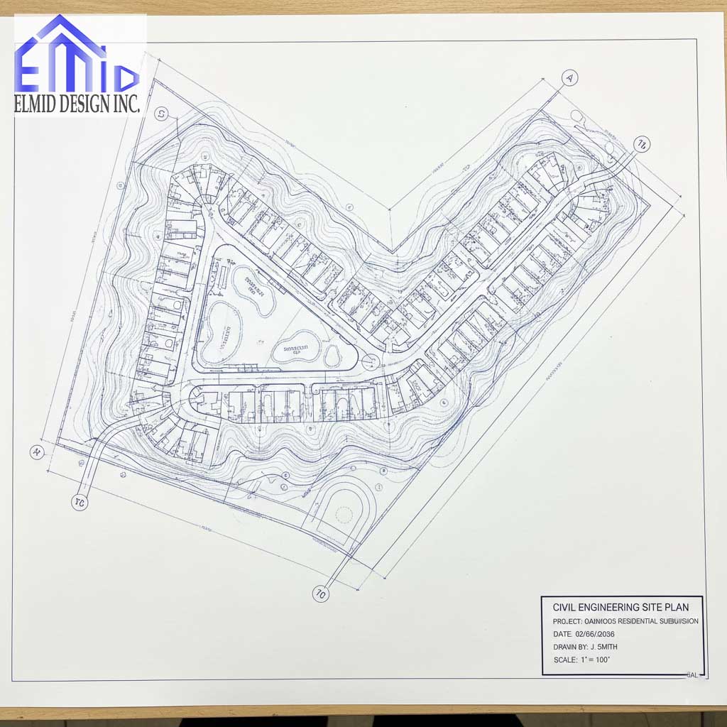
Civil engineering drawings Ontario contain elements that help readers understand project details easily. Title blocks show dates, sheet numbers, and project names. Property lines outline legal boundaries that shape design choices. Contours reveal slope direction and guide grading work. Spot elevations show exact height values that support layout accuracy. Drainage symbols mark swales, ditches, manholes, and pipes. Utility details outline water, sanitary, and storm connections. Legends explain symbols so readers interpret information correctly. Scales help teams measure distances with precision. These elements support clear planning across Ontario developments.
Grading Plans in Ontario Civil Engineering Drawings
Civil engineering drawings Ontario include grading plans that control slope behavior on each site. Small changes in elevation influence stormwater movement and soil strength. Proper grading protects structures from settlement and improves long term stability. Ontario municipalities set slope limits that reduce erosion and keep sites safe. Engineers study land conditions before selecting cut and fill values. Grading plans guide contractors during excavation and shaping. Clear slopes reduce drainage issues and improve project flow. Grading plans also support safe landscaping and future maintenance.
Drainage Plans Within Ontario Engineering Drawings
Civil engineering drawings Ontario include drainage plans that manage stormwater during heavy rainfall. These plans guide water toward safe outlets and prevent property flooding. Engineers identify low areas that require shaping to avoid ponding. Swales and ditches move water away from roads and homes. Storm sewers collect runoff and carry it to designated systems. Ontario conservation authorities require strong control to protect natural areas. Drainage plans include erosion control strategies that reduce soil loss. Clear drawings reduce mistakes and help teams complete work safely.
Utility Plans and Servicing Requirements Across Ontario
Civil engineering drawings Ontario include utility plans that guide safe installation of essential services. Designers map water, sanitary, and storm sewer routes clearly. Separation distances protect crews and reduce installation risks. Hydrant locations improve fire protection and follow municipal rules. Utility plans must align with grading and drainage layouts to avoid conflicts. Survey data supports accurate placement and reduces design errors. Review teams check spacing to ensure safety and reliability. Strong servicing plans improve community function and long term performance.
Road Design and Access Planning in Ontario Drawings
Civil engineering drawings Ontario include road design information that supports safe travel. Engineers plan street widths that fit expected traffic levels. Intersections require clear views and safe turning space. Sidewalks direct pedestrian movement and protect accessibility. Emergency vehicles need routes that support fast entry during urgent events. Grading ties road surfaces to surrounding land. Drainage design keeps water away from pavements during storms. Strong road layouts improve safety and support long term community growth.
Survey Data and Its Role in Ontario Drawings
Civil engineering drawings Ontario rely on accurate survey data to guide design decisions. Surveyors collect measurements that show property limits and elevation changes. These values support grading, drainage, and utility placement. Ontario land survey standards ensure consistent accuracy across projects. Engineers study survey points to understand slope behavior. Updated surveys reduce errors during construction. Clear data improves design confidence and supports municipal review.

Ontario Regulations Affecting Civil Engineering Drawings
Civil engineering drawings Ontario follow strict regulations that protect safety and environmental quality. Ontario municipalities use engineering standards that guide grading, drainage, and utility design. Conservation authority rules also influence stormwater planning and erosion control. Ontario Building Code requirements shape site layout, servicing, and access features. These rules create safe communities and reduce long term risks. Clear drawings help reviewers confirm compliance during each approval stage. Strong regulatory alignment improves construction outcomes across the province.
Typical Workflow for Civil Engineering Drawings Ontario
Civil engineering drawings Ontario follow a workflow that supports accuracy and clear communication. The process often begins with a site visit that reveals early design concerns. Survey teams collect detailed information that guides engineering decisions. Engineers prepare conceptual layouts before refining grading, drainage, and servicing plans. Review cycles improve clarity and resolve conflicts. Owners receive updated drawings that reflect design changes. Municipal review also confirms compliance with local and provincial requirements. A structured workflow improves project results.
Common Issues Found in Ontario Civil Engineering Drawings
Civil engineering drawings Ontario face issues when important details receive limited attention. Incorrect slopes create drainage problems that affect structures. Utility conflicts appear when service lines cross without proper spacing. Outdated survey information leads to grading errors during construction. Missing notes reduce clarity and increase confusion. Review delays occur when drawings lack essential details. These problems increase project risk and cost for owners and contractors. Careful review reduces these challenges and improves long term performance.
Modern Technology Improving Ontario Engineering Drawings
Civil engineering drawings Ontario benefit from strong technology that improves accuracy and design clarity. Engineers use digital terrain models to study slope behavior. Software tools help test stormwater flow during heavy rainfall. Mapping programs highlight soil patterns that influence layout decisions. Updated digital files allow fast revisions during review. Contract teams understand design intent more clearly through visual tools. Technology supports better decision making and improves long term safety across Ontario projects.
Cost Factors for Civil Engineering Drawings Ontario
Civil engineering drawings Ontario involve cost factors that vary across project types. Property size influences survey time and design complexity. Steeper land requires more grading analysis and detailed planning. Drainage and servicing requirements also affect design effort. Municipal review cycles may add time if drawings require revisions. Owners receive cost estimates that reflect clear design needs. Accurate drawings reduce rework and support predictable budgets. Strong design planning improves long term value for developments.
Why Ontario Developers Depend on Professional Engineering Firms
Civil engineering drawings Ontario improve when professional engineering firms manage each design stage. Skilled engineers understand provincial standards and municipal requirements. Detailed analysis helps avoid costly construction issues. Strong communication supports owners during each review stage. Contractors value accurate drawings because clear instructions improve efficiency. Reliable engineering work strengthens public safety and long term infrastructure performance. Developers choose experienced firms because quality design reduces risk.
Elmid Design Inc Supporting Ontario Development
Civil engineering drawings Ontario benefit from firms that understand complex provincial requirements. Elmid Design Inc delivers strong grading, drainage, and servicing plans that support safe development. Experienced engineers use careful analysis to create clear and dependable drawings. Owners trust the company because communication stays consistent throughout design and review stages. Quality work helps projects meet Ontario standards and maintain long term stability.
Advanced Design Steps for Civil Engineering Drawings Ontario
Civil engineering drawings Ontario improve through advanced design steps that strengthen every project stage. Moreover, engineers study slope behavior through digital terrain models that show how land responds during rainfall. Additionally, designers test stormwater flow to ensure safe water movement across each site. Furthermore, utility routes receive careful checks that prevent conflicts and improve long term service reliability. Updated survey data supports better decisions, and clear revisions improve accuracy. Altogether, advanced design steps create safer and more dependable Ontario developments.
Coordination Across Ontario Projects Strengthens Engineering Drawings
Civil engineering drawings Ontario become more reliable when strong coordination guides each planning stage. Surveyors gather accurate boundary and elevation information before engineering begins. Moreover, engineers convert this information into grading, drainage, and servicing plans that support safe development. Additionally, contractors provide field insight that improves layout decisions. Owners also confirm project goals that shape design outcomes and reduce confusion. Altogether, strong coordination supports safe construction results across Ontario communities.
Technology Supporting Civil Engineering Drawings Ontario
Civil engineering drawings Ontario benefit from technology that improves clarity and efficiency. Engineers use digital drafting tools that display grading and drainage details with greater precision. Moreover, mapping programs reveal soil patterns that influence design choices. Additionally, stormwater modeling tools test water movement during extreme weather. Updated digital files allow fast revisions and clearer communication. Furthermore, visual tools help owners understand layout changes quickly. Altogether, technology strengthens Ontario engineering design.
Field Verification and Its Importance in Ontario
Civil engineering drawings Ontario depend on field verification that confirms real site conditions. Survey teams inspect slopes, soils, and boundaries before final design decisions proceed. Moreover, field checks reveal issues early, which supports safer and more accurate revisions. Additionally, engineers adjust grading, drainage, and utility plans when conditions demand changes. Crews avoid costly delays because verification removes uncertainty. Altogether, field verification strengthens project safety and improves final outcomes.
Long Term Safety Supported by Civil Engineering Drawings Ontario
Civil engineering drawings Ontario support long term safety through detailed analysis and responsible design practices. Moreover, proper grading directs water safely and reduces erosion. Additionally, effective drainage planning protects structures and roads from storm damage. Utility spacing improves maintenance safety and reduces future conflict risks. Road layout information supports emergency access and daily travel. Altogether, well prepared drawings improve community stability and protect long term infrastructure performance.
Contractor Advantages When Drawings Are Clear in Ontario
Civil engineering drawings Ontario help contractors work efficiently by showing clear grading, drainage, and servicing details. Moreover, contractors rely on precise elevations to control soil movement. Additionally, drainage layouts support correct installation paths and reduce field confusion. Utility details prevent trench conflicts and protect worker safety. Furthermore, consistent drawings reduce delays and help maintain schedules. Altogether, clear engineering drawings support strong performance across Ontario construction projects.
Cost Savings Supported by Accurate Ontario Engineering Drawings
Civil engineering drawings Ontario create cost savings through strong planning and clear communication. Moreover, accurate grading plans reduce unnecessary soil movement. Additionally, proper drainage design lowers long term repair costs. Utility layouts reduce conflicts, which limits expensive field changes. Project teams avoid delays because drawings present reliable information. Owners gain predictable budgets and improved confidence. Altogether, careful design supports long term financial value.
Benefits for Property Owners Across Ontario
Civil engineering drawings Ontario help property owners understand land behavior and project requirements. Moreover, drawings show slopes, drainage patterns, and service locations with clarity. Additionally, owners make informed decisions because information stays simple and organized. Layout details reduce stress during planning and construction. Furthermore, clear drawings support safe development and future improvements. Altogether, reliable engineering information increases confidence and project success.
How Engineering Drawings Connect Planning and Construction in Ontario
Civil engineering drawings Ontario link design planning with practical construction steps. Moreover, drawings show each requirement for grading, drainage, and service installation. Engineers create layouts that guide crews through each construction stage. Additionally, owners understand project goals through clear diagrams and notes. Crews follow drawings to maintain safety and accuracy. Altogether, strong drawings support organized progress and safe development across Ontario.
Frequently Asked Questions
What are civil engineering drawings Ontario used for
Civil engineering drawings Ontario guide grading, drainage, servicing, and access planning to support safe construction and long term site performance.
Why do Ontario projects require grading plans
Grading plans direct water movement and prevent erosion. Proper grading protects structures and maintains soil stability.
Who prepares civil engineering drawings in Ontario
Licensed engineers prepare civil engineering drawings Ontario because specialized training ensures safe and accurate design choices.
How do these drawings help property owners
Civil engineering drawings Ontario give owners clear information that supports planning decisions and reduces project risks.
When should drawings be updated in Ontario projects
Civil engineering drawings Ontario require updates when field conditions change or when new information improves design clarity.
Why are drainage plans important across Ontario
Drainage plans control stormwater and prevent flooding. Strong design protects homes, roads, and landscapes.
How do contractors use civil drawings during construction
Contractors follow civil engineering drawings Ontario to guide grading, trenching, drainage shaping, and utility placement.
Do small Ontario projects need engineering drawings
Many small projects require drawings to meet grading or servicing rules and maintain safe development standards.
How long do engineering drawings take to complete
Timelines depend on project size and complexity. Larger developments require more review and design detail.
How do strong civil drawings reduce construction costs
Civil engineering drawings Ontario reduce errors, improve scheduling, and prevent costly redesign during construction.

Elmid Design Inc as a Trusted Engineering Firm in Ontario
Elmid Design Inc strengthens civil engineering drawings Ontario projects through precise grading, drainage, and servicing design, and the firm supports development with strong technical knowledge, clear communication, and a Professional Engineers Ontario certificate of authorization that ensures each project meets strict provincial standards while helping owners and builders achieve safe and dependable long term results.
Geographic Locations That We Service:
Our Licensed Professional Engineers specializing in Engineered Site Grading Plans offer the best-engineered site grading plan, lot grading and erosion plan, and drainage plan to obtain site plan approval and building permits in Ontario, including a wide range of municipalities. Each area boasts unique features and requirements, making our tailored approach essential for success.
Toronto and Surrounding Areas
In the vibrant heart of Ontario, we service Toronto (City of Toronto) and surrounding areas. Additionally, we cover Oshawa (City of Oshawa), Pickering (City of Pickering), and Clarington (Municipality of Clarington). Furthermore, our expertise extends to Ajax (Town of Ajax), Whitby (Town of Whitby), Brock (Township of Brock), Scugog (Township of Scugog and Uxbridge (Township of Uxbridge).
Halton Region
Moving to the Halton Region, our services encompass Burlington (City of Burlington) and Halton Hills (Town of Halton Hills). Also included are Milton (Town of Milton) and Oakville (Town of Oakville).
Peel Region
In the Peel Region, we provide services in Brampton (City of Brampton), Mississauga (City of Mississauga), and Caledon (Town of Caledon).
York Region
Our services in the York Region cover Vaughan (City of Vaughan), Aurora (Town of Aurora), and East Gwillimbury (Town of East Gwillimbury). We also cater to Georgina (Town of Georgina), Markham (City of Markham), Newmarket (Town of Newmarket), Richmond Hill (City of Richmond Hill), Whitchurch-Stouffville (Town of Whitchurch-Stouffville), King (Township of King), and Bradford-West Gwillimbury (Town of Bradford-West Gwillimbury). Each municipality here offers a distinct setting, requiring our specialized approach.
Other Southern Ontario Cities and Towns
We also serve many other cities and towns in Southern Ontario. These include Hamilton (City of Hamilton), St. Catharines (City of St. Catharines), Niagara on the Lake (Town of Niagara on the Lake), Brant (County of Brant), Cambridge (City of Cambridge), Kitchener (City of Kitchener), Waterloo (City of Waterloo), and Woodstock (City of Woodstock). Furthermore, we operate in Guelph (City of Guelph), Centre Wellington (Township of Centre Wellington), Shelburne (Town of Shelburne), Orangeville (Town of Orangeville), New Tecumseth (Town of New Tecumseth), Essa (Town of Essa), Collingwood (Town of Collingwood), Wasaga Beach (Town of Wasaga Beach), Barrie (City of Barrie), Midland (Town of Midland), Orillia (City of Orillia), Ramara (Town of Ramara), Minden Hills (Town of Minden Hills), North Kawartha (Town of North Kawartha), Kawartha Lakes (City of Kawartha Lakes), Peterborough (City of Peterborough), Selwyn (Town of Selwyn), and Brighton (Municipality of Brighton).